Holleran et al., 2015
Quantifying soil and critical zone variability in a forested catchment through digital soil mapping
Holleran M., Levi M., and Rasmussen C. (2015)
SOIL 1(1): 47-64
-
Catalina-Jemez, Shale Hills, GRAD STUDENT
-
Catalina-Jemez, INVESTIGATOR
Abstract
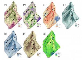
Maps of predicted soil properties including (a) clay percent, (b) KCl pH, (c) Na, (d) soil depth,(e) clay stocks, (f) carbon stocks, and (g) Na mass flux for the study catchment. Final maps are the back-transformed summation of logit-transformed regression estimations and interpolated residuals.
Quantifying catchment-scale soil property variation yields insights into critical zone evolution and function. The objective of this study was to quantify and predict the spatial distribution of soil properties within a high-elevation forested catchment in southern Arizona, USA, using a combined set of digital soil mapping (DSM) and sampling design techniques to quantify catchment-scale soil spatial variability that would inform interpretation of soil-forming processes. The study focused on a 6 ha catchment on granitic parent materials under mixed-conifer forest, with a mean elevation of 2400 m a.s.l, mean annual temperature of 10 °C, and mean annual precipitation of ~ 85 cm yr−1. The sample design was developed using a unique combination of iterative principal component analysis (iPCA) of environmental covariates derived from remotely sensed imagery and topography, and a conditioned Latin hypercube sampling (cLHS) scheme. Samples were collected by genetic horizon from 24 soil profiles excavated to the depth of refusal and characterized for soil mineral assemblage, geochemical composition, and general soil physical and chemical properties. Soil properties were extrapolated across the entire catchment using a combination of least-squares linear regression between soil properties and selected environmental covariates, and spatial interpolation or regression residual using inverse distance weighting (IDW). Model results indicated that convergent portions of the landscape contained deeper soils, higher clay and carbon content, and greater Na mass loss relative to adjacent slopes and divergent ridgelines. The results of this study indicated that (i) the coupled application of iPCA and cLHS produced a sampling scheme that captured the greater part of catchment-scale soil variability; (ii) application of relatively simple regression models and IDW interpolation of residuals described well the variance in measured soil properties and predicted spatial correlation of soil properties to landscape structure; and (iii) at this scale of observation, 6 ha catchment, topographic covariates explained more variation in soil properties than vegetation covariates. The DSM techniques applied here provide a framework for interpreting catchment-scale variation in critical zone process and evolution. Future work will focus on coupling results from this coupled empirical–statistical approach to output from mechanistic, process-based numerical models of critical zone process and evolution.
Citation
Holleran M., Levi M., and Rasmussen C. (2015): Quantifying soil and critical zone variability in a forested catchment through digital soil mapping. SOIL 1(1): 47-64. DOI: 10.5194/soil-1-47-2015
 This Paper/Book acknowledges NSF CZO grant support.
Explore Further


