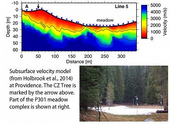
Holbrook et al., 2014
Geophysical constraints on deep weathering and water storage potential in the Southern Sierra Critical Zone Observatory
Holbrook, W.S., Riebe, C.S., Elwaseif, M., Hayes, J.L., Harry, D. L., Basler-Reeder, K., Malazian, A., Dosseto, A., Hartsough, P. C., and Hopmans, J. W. (2014)
Earth Surface Processes and Landforms, 39:366-380.
-
Boulder, Calhoun, Eel, Reynolds, Sierra, COLLABORATOR
-
Sierra, INVESTIGATOR
-
Shale Hills, Sierra, INVESTIGATOR, COLLABORATOR
-
Sierra, GRAD STUDENT
-
Luquillo, Sierra, COLLABORATOR
-
Sierra, INVESTIGATOR
-
Sierra, COLLABORATOR
Abstract
The conversion of bedrock to regolith marks the inception of critical zone processes, but the factors that regulate it remain poorly understood. Although the thickness and degree of weathering of regolith are widely thought to be important regulators of the development of regolith and its water-storage potential, the functional relationships between regolith properties and the processes that generate it remain poorly documented. This is due in part to the fact that regolith is difficult to characterize by direct observations over the broad scales needed for process-based understanding of the critical zone. Here we use seismic refraction and resistivity imaging techniques to estimate variations in regolith thickness and porosity across a forested slope and swampy meadow in the Southern Sierra Critical Zone Observatory (SSCZO). Inferred seismic velocities and electrical resistivities image a weathering zone ranging in thickness from 10 to 35 m (average = 23 m) along one intensively studied transect. The inferred weathering zone consists of roughly equal thicknesses of saprolite (P-velocity < 2 km s−1) and moderately weathered bedrock (P-velocity = 2–4 km s−1). A minimum-porosity model assuming dry pore space shows porosities as high as 50% near the surface, decreasing to near zero at the base of weathered rock. Physical properties of saprolite samples from hand augering and push cores are consistent with our rock physics model when variations in pore saturation are taken into account. Our results indicate that saprolite is a crucial reservoir of water, potentially storing an average of 3 m3 m−2 of water along a forested slope in the headwaters of the SSCZO. When coupled with published erosion rates from cosmogenic nuclides, our geophysical estimates of weathering zone thickness imply regolith residence times on the order of 105 years. Thus, soils at the surface today may integrate weathering over glacial–interglacial fluctuations in climate. Copyright © 2013 John Wiley & Sons, Ltd.
Citation
Holbrook, W.S., Riebe, C.S., Elwaseif, M., Hayes, J.L., Harry, D. L., Basler-Reeder, K., Malazian, A., Dosseto, A., Hartsough, P. C., and Hopmans, J. W. (2014): Geophysical constraints on deep weathering and water storage potential in the Southern Sierra Critical Zone Observatory. Earth Surface Processes and Landforms, 39:366-380.. DOI: 10.1002/esp.3502
 This Paper/Book acknowledges NSF CZO grant support.
Explore Further


