Bales et al., 2018
Spatially distributed water-balance and meteorological data from the Wolverton catchment, Sequoia National Park, California
BALES, R.C., STACY, E.M., MENG, X., CONKLIN, M.H., KIRCHNER, P.B., and ZHENG, Z (2018)
Earth System Science Data, 10
-

Sierra, INVESTIGATOR
-

Sierra, STAFF
-
Sierra, STAFF
-

Sierra, INVESTIGATOR
-

Sierra, GRAD STUDENT
Abstract
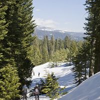
Accurate water-balance measurements in the seasonal, snow-dominated Sierra Nevada are important for forest and downstream water management. However, few sites in the southern Sierra offer detailed records of the spatial and temporal patterns of snowpack and soil-water storage and the fluxes affecting them, i.e., precipitation as rain and snow, snowmelt, evapotranspiration, and runoff. To explore these stores and fluxes we instrumented the Wolverton basin (2180–2750m) in Sequoia National Park with distributed, continuous sensors. This 2006–2016 record of snow depth, soil moisture and soil temperature, and meteorological data quantifies the hydrologic inputs and storage in a mostly undeveloped catchment. Clustered sensors record lateral differences with regards to aspect and canopy cover at approximately 2250 and 2625m in elevation, where two meteorological stations are installed. Meteorological stations record air temperature, relative humidity, radiation, precipitation, wind speed and direction, and snow depth. Data are available at hourly intervals by water year (1 October–30 September) in non-proprietary formats from online data repositories (https://doi.org/10.6071/M3S94T).
Citation
BALES, R.C., STACY, E.M., MENG, X., CONKLIN, M.H., KIRCHNER, P.B., and ZHENG, Z (2018): Spatially distributed water-balance and meteorological data from the Wolverton catchment, Sequoia National Park, California. Earth System Science Data, 10. DOI: 10.5194/essd-10-2115-2018
 This Paper/Book acknowledges NSF CZO grant support.
Explore Further
