Angelo Coast Range Reserve
The Heath & Marjorie Angelo Coast Range Reserve is a Berkeley-administered research reserve in the University of California Natural Reserve System. It covers 31 km2 of steep forested terrain, 5 km of the upper South Fork Eel River and entire watersheds of Elder Creek and several other tributaries. The Angelo Reserve has hosted > 25 years of prior NSF-funded field research and was the first collaborative field site for an NSF Science and Technology Center, the National Center for Earth Surface Dynamics (NCED) (2002-2012).
31 km2 Area
120 - 1260 m Elev
10.1 °C Temp
Parent Field Area:
Eel River Watershed ▲
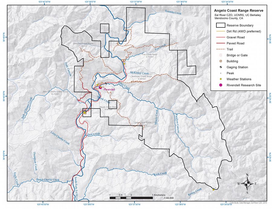
Map of the Angelo Coast Range Reserve (Collin Bode, Eel River CZO, UCB, 2014)
-
Setting & Research
Heavy precipitation in the region feeds large streams that swell with winter rains and shrink during summer drought. The U.S.Geological Survey (USGS) estimates that at least 65 percent of the rainfall here eventually reaches the Eel River as runoff. A 5-kilometer reach (3 miles) of the South Fork of the Eel River winds through the reserve, and its flow fluctuates greatly. Extremes recorded since the early 1950′s range from a high flow of 20,000 cubic feet per second (CFS) in December 1955 to a low flow of 0.45 cfs in August 1977.
Watersheds free from dams and logging are rare in the Coast Range, yet three undisturbed watersheds are completely contained within the boundaries of the reserve. The Elder Creek watershed - at 16.8 kilometers (6.5 square miles), the largest of the three – is registered as a National Natural History Landmark by the National Park Service. In recognition of the water’s purity, the USGS operates a Benchmark Hydrological Station on Elder Creek, one of 57 benchmark stations throughout the United States. Hydrologic data have been collected here continuously since 1967. Fox Creek, another large perennial stream, has a watershed of 2.6 square kilometers (1.0 square miles). It dissects a river terrace near Wilderness lodge, where its water has been tapped for domestic use since the homesteaders’ time. The smaller Skunk Creek watershed provides the coolest channel and a very moist riparian zone for comparative studies. Additionally, there are numerous intermittent streams, springs, and seeps throughout the reserve.
Natural History
The Angelo Coast Range Reserve has aquatic and terrestrial habitats. With elevations ranging from 378-1290 m, the steep, dissected terrain harbors redwood groves, mixed conifer-deciduous forest, upland Douglas fir and mixed conifer-decidious forests, nine meadows on upland river terraces, and chaparral at higher elevations, particularly along ridgelines.
Because the Angelo Reserve lies east of Elkhorn Ridge, a high region of the coast range, it is shielded from maritime fog. Consequently, it has more temperature extremes, drier summers, and more elevationally stratified vegetation than might be expected in a habitat only 12-15 miles east of the Pacific Ocean. Aquatic habitats include a salmon-bearing mainstream river and tributary streams, and seasonal seeps and meadow wetlands. Notable fauna include the Pacific giant salamander, the Olympic salamanders, river otters, flying squirrels, black bears, the threatened northern spotted owl, lamprey eels (for which the river was named), coho and chinook salmon, and steelhead trout. The reserve protects one of the largest tracts of coastal Douglas fir-Coast Redwood forest remaining in the state of California, and a 5 km stretch of the South Fork of the Eel River designated as a Wild and Scenic River. Protected spawning and rearing habitat for salmonids and other fishes occurs in the mainstem South Fork and in three of its perennial tributaries within the Reserve. and there are cool salamanders in the seeps between the river channels.
-
Data
Angelo Coast Range Reserve - Precipitation, Rainfall Chemistry, Overland Water Chemistry, Stream Water Chemistry, Throughfall Chemistry, Groundwater Chemistry, Rock Moisture, Stable Isotopes - Stable isotope analysis of water samples (2014-2016)
1 components • Angelo Coast Range Reserve • Biogeochemistry, Water Chemistry • Dawson, Todd E.; Wong, Christopher S.; Rempe, Daniella; Hahm, JesseAngelo Reserve - Meteorology - Weather Stations (4) (2007-2015)
4 components • Angelo Coast Range Reserve • Climatology / Meteorology • Steel, Peter; Dietrich, William; Power, Mary; Bode, Collin; Stromberg, Mark; McCurdy, GregAngelo Reserve - Streamflow / Discharge - South Fork Eel River (2008-2015)
2 components • Angelo Coast Range Reserve • Hydrology • Dietrich, William; Power, Mary; Bode, Collin; Steel, PeterEel River to Rivendell - GIS/Map Data - Research and Watershed GIS Boundaries (2004-2015)
1 components • Rivendell, Angelo Coast Range Reserve, Eel River Watershed • GIS / Remote Sensing • Collin Bode; USGSSouth Fork Eel River Headwaters - LiDAR, Digital Elevation Model (DEM) - Bare-earth elevation model and hillshade (2004)
1 components • Angelo Coast Range Reserve, Eel River Watershed • GIS / Remote Sensing • Mary Power; Bill Dietrich; Collin Bode
Explore Further
