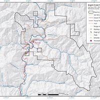
Eel River Watershed

The Eel River Watershed (9,540 km2) is a steep mostly undammed Northern California coastal river eroding rapidly through mechanically weak rock with active uplift. Both watershed-climate-ocean productivity investigations and education & outreach have occurred here (supported by prior NSF funds and in collaboration with Friends of the Eel River and the Eel River Recovery Project).
9540.0 km2 Area
Areas within Eel River Watershed
-
Setting & Research
The Eel River watershed and its southern neighbor, the Russian River watershed offer an ideal opportunity to conduct fine scale research within the critical zone, follow currencies to the atmosphere, streams and ocean as they drive and are altered by a succession of ecosystems, and explore consequences for management practices caused by changing climate and land use. The Eel and Russian rivers are the two large river systems of coastal Northern California, with the Eel draining northward through mostly timber and grazing lands (but with increasing irrigated agricultural use), and the Russian draining to the south through increasing vineyard and housing development towards Santa Rosa, the largest city in the basin. Although more developed than the Eel, only about 13% of the Russian watershed is in agricultural lands. The Eel has two dams in the mainstem headwaters where the Potter Valley diversion reroutes Eel flow into the Russian River. The Russia River has two dams, one in the headwaters (that receives flow from the Eel), and one on a major tributary, Dry Creek, farther down the river. But like other river systems in active agricultural lands, the Russian has some 500 small dams along the tributaries. Salmon (including the endangered Coho Salmon) spawn and migrate in both the Eel and Russian; their populations are in great decline, which is attributed to many factors, including reduced summer base flows and elevated temperatures.
The Eel and Russian have over geologic time competed for drainage area at their mutual headwaters as tectonic pulses swept through the region. The underlying geology of this region records the complex accreted terrain of the North American plate margin, but there are three dominant rock types of the Franciscan terrain: the Coastal Belt (argillite, sandstones and conglomerates), the Central Belt (mélange) and the Eastern Belt (metasedimentary and metavolcanic rocks), with the Central Belt swept by large, active earthflows in the mechanically weak rocks. Most of the Eel River watershed emerged above sea level in just the past 4 million years and uplift rates increase from south towards the north from about 0.4 mm /yr to greater than 4 mm/yr. Despite high uplift and erosion rates a deep and well–developed, hydrologically active weathered bedrock zone has formed on Coastal Belt rocks.
-
Data
Eel River and South Fork Eel River - LiDAR, Digital Elevation Model (DEM) (2009)
1 components • Eel River Watershed • GIS / Remote Sensing • Jonathan Perkins; Noah FinneganEel River to Rivendell - GIS/Map Data - Research and Watershed GIS Boundaries (2004-2015)
1 components • Rivendell, Angelo Coast Range Reserve, Eel River Watershed • GIS / Remote Sensing • Collin Bode; USGSNational - LiDAR, Land Cover, GIS/Map Data - OpenTopography (2010-2017)
18 components • Boulder Creek Watershed, Eel River Watershed, Jemez River Basin, Reynolds Creek Experimental Watershed, Susquehanna Shale Hills Critical Zone Observatory, Northeastern Puerto Rico and the Luquillo Mountains, Sangamon River Basin, Clear Creek Watershed, Calhoun Critical Zone Observatory, Providence Creek Headwater Catchments (1660 - 2115 m elevation) • Geomorphology, GIS / Remote Sensing, Hydrology, Biology / Ecology • National Center for Airborne Laser Mapping; Boulder Creek Critical Zone Observatory; Calhoun Critical Zone Observatory; University of Arizona; University of California Merced; Valles Caldera National Preserve; Bandelier National Monument; National Park Service; Jemez River Basin and Santa Catalina Mountains Critical Zone Observatory; Luquillo Critical Zone Observatory; Reynolds Creek CZO; Eel River CZO; Shale Hills CZONational - Stream Water Chemistry - Cations, Anions, Metals (1982-2015)
1 components • Bisley, Betasso, East Peak, Marshall Gulch (High-Elevation), Providence Creek Subcatchment P301, Providence Creek Subcatchment P303, Providence Creek Subcatchment P304, Eel River Watershed, Puente Roto, Rio Blanco, Rio Icacos, Susquehanna Shale Hills Critical Zone Observatory • Biogeochemistry, Biology / Ecology, Hydrology, Water Chemistry • Hyojin, Kim; Bishop, Jim; Dietrich, William; Fung, Inez; McDowell, William H.; Brantley, Susan L.; Hoagland, Beth; Sullivan, Pamela L.; Cain, Molly; Neal, Andrew; Fisher, Jessica; Russo, Tess; Niwot Ridge LTER; Liu, Fengjing; Chorover, Jon; Troch, Peter; McIntosh, Jennifer; Brooks, Paul; Abramson, Nate; Heidbuechel, Ingo; Amistadi, Mary Key; Alexander Pedron, Shawn; Chorover, Jon; Troch, Peter; Corley, Timothy; Zapata-Rios, Xavier; Losleben, Mark; Condon, KatherineSouth Fork Eel River Headwaters - LiDAR, Digital Elevation Model (DEM) - Bare-earth elevation model and hillshade (2004)
1 components • Angelo Coast Range Reserve, Eel River Watershed • GIS / Remote Sensing • Mary Power; Bill Dietrich; Collin Bode -
Partner Organizations
Explore Further
