Riebe and Chorover, 2014
Report on Drilling, Sampling, and Imaging the Depths of the Critical Zone, an NSF Workshop
Riebe, C. S. and Chorover, J. (2014)
Open Project Report to the Critical Zone Community Cross-CZO National
-

Sierra, INVESTIGATOR
-

Catalina-Jemez, INVESTIGATOR
Abstract
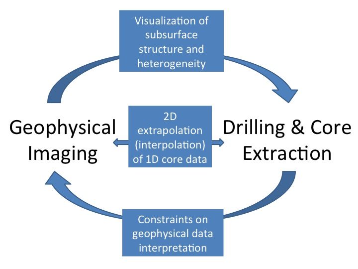
Schematic illustrating connections between drilling and geophysical imaging. Drilling generates boreholes for direct observations of deep CZ architecture (e.g., fracture spacing and orientation in the subsurface) and for sampling of circulating fluids at depth. Meanwhile, core extraction during drilling provides materials for measurements of critical zone properties (e.g., porosity, bulk geochemistry, and microbial makeup of regolith). Geophysical imaging can provide visualization of the subsurface structure and heterogeneity of CZ properties; this can be used to interpolate between multiple boreholes and extrapolate beyond them to characterize the subsurface over broad spatial scales.
This report summarizes outcomes of an NSF-supported workshop, entitled Drilling, Sampling, and Imaging the Depths of the Critical Zone, which was conducted on October 24–26, 2013, in the days preceding the annual meeting of the Geological Society of America, in Denver Colorado. The workshop hosted 49 participants from 35 institutions scattered over 2 continents. Participants represented diverse disciplines, including geophysics, geochemistry, geomorphology, soil science, hydrology, and drilling technologies. Participants were also diverse in career level, ranging from second-year graduate students to directors of national and international facilities and programs. Over the course of two days of presentations, breakout groups, and plenary discussions, the following 10 outcomes, recommendations, and conclusions were reached: (1) There is strong interest and sense of excitement around advancing deep critical zone (CZ) research through a program of drilling, sampling, and geophysical imaging; (2) The CZ research community has now embarked on a long-term effort to unveil the deep critical zone at a scale appropriate to enhanced understanding of processes vital to the evolution of the CZ and to the prediction of CZ response to change in the future; (3) Shallow drilling and geophysical imaging projects do not have a funding source of their own, yet there is a need expressed across the community, including multiple disciplines, to support both drilling and geophysical studies of the deep CZ; (4) Overcoming limitations imposed by disciplinary silos will require new connections between CZ scientists, near-surface geophysicists, and experts in drilling technologies (some promising connections were made at the workshop); (5) Funding mechanisms must accept that proposals to study the CZ could (and often should) have strong geophysics and drilling components; funding of such work could alternatively be structured around a service model (similar to NCALM for LiDAR imaging) over the long-term; (6) Drilling and geophysics need to go hand in hand to capitalize on potentially powerful synergies and to understand the great compositional and spatial variability of the CZO; (7) The observations that are made using drilling and geophysical imaging should be driven from a hypothesis-testing framework; (8) The CZOs have already made many of the measurements needed to simultaneously test and demonstrate the value of geophysics and drilling with abundant existing data to fuel hypotheses; (9) A program of cross- disciplinary education is recommended to grow a new breed of CZ scientists who are educated in deep CZ investigation methods including drilling and geophysics; a good way to start may be to follow the REU model already established at NSF; (10) A panel of experts should be formed to serve in an advisory role for the growing community of scientists interested in deep CZ research using drilling and geophysical imaging.
Citation
Riebe, C. S. and Chorover, J. (2014): Report on Drilling, Sampling, and Imaging the Depths of the Critical Zone, an NSF Workshop. Open Project Report to the Critical Zone Community.
Associated Files
Drilling, Sampling, and Imaging the Depths of the Critical Zone
(9 MB pdf)
This report summarizes outcomes of an NSF-supported workshop, entitled Drilling, Sampling, and Imaging the Depths of the Critical Zone, which was conducted on October 24–26, 2013, in the days preceding the annual meeting of the Geological Society of America, in Denver Colorado.
Explore Further
