Fang et al., 2017
Study of the Spatiotemporal Characteristics of Meltwater Contribution to the Total Runoff in the Upper Changjiang River Basin
Fang Y.-H., Zhang X., Niu G.-Y., Zeng W., Zhu J., Zhang T. (2017)
Water 9(3): 165
-

Catalina-Jemez, INVESTIGATOR, COLLABORATOR
Abstract
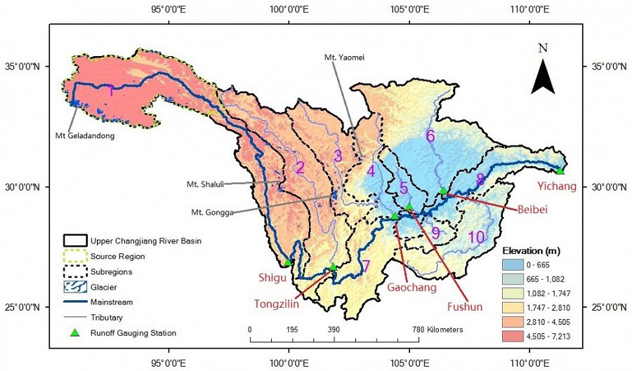
Map of the Upper Changjiang River Basin where blue shaded areas are the glaciers
Melt runoff (MR) contributes significantly to the total runoff in many river basins. Knowledge of the meltwater contribution (MCR, defined as the ratio of MR to the total runoff) to the total runoff benefits water resource management and flood control. A process-based land surface model, Noah-MP, was used to investigate the spatiotemporal characteristics of MR and MCR in the Upper Changjiang River (as known as Yangtze River) Basin (UCRB) located in southwestern China. The model was first calibrated and validated using snow cover fraction (SCF), runoff, and evapotranspiration (ET) data. The calibrated model was then used to perform two numerical experiments from 1981 to 2010: control experiment that considers MR and an alternative experiment that MR is removed. The difference between two experiments was used to quantify MR and MCR. The results show that in the entire UCRB, MCR was approximately 2.0% during the study period; however, MCR exhibited notable spatiotemporal variability. Four sub-regions over the Qinghai-Tibet Plateau (QTP) showed significant annual MCR ranging from 3.9% to 6.0%, while two sub-regions in the low plain regions showed negligible annual MCR. The spatial distribution of MCR was generally consistent with the distribution of glaciers and elevation distribution. Mann-Kendall (M-K) tests of the long-term annual MCR indicated that the four sub-regions in QTP exhibited increasing trends ranging from 0.01%/year to 0.21%/year during the study period but only one displayed statistically significant trend. No trends were found for the peak time (PT) of MR and MCR, in contrast, advancing trend were observed for the center time (CT) of MR, ranging from 0.01 months/year to 0.02 months/year. These trends are related to the changes of air temperature and precipitation in the study area.
Citation
Fang Y.-H., Zhang X., Niu G.-Y., Zeng W., Zhu J., Zhang T. (2017): Study of the Spatiotemporal Characteristics of Meltwater Contribution to the Total Runoff in the Upper Changjiang River Basin. Water 9(3): 165. DOI: 10.3390/w9030165
 This Paper/Book acknowledges NSF CZO grant support.
Explore Further
