Calhoun CZO Research Area 3
The largest of the research areas at the Calhoun, Research Area 3 encompasses the Holcombe's Branch watershed. This is the most intensely studied area in the CCZO for ecohydrology, geophysics, and soil organic carbon dynamics research.
6.5 km2 Area
108 - 195 m Elev
16 °C Temp
1250 mm Precip
Parent Field Area:
Calhoun Critical Zone Observatory ▲
Holcombe's Branch
-
Setting & Research
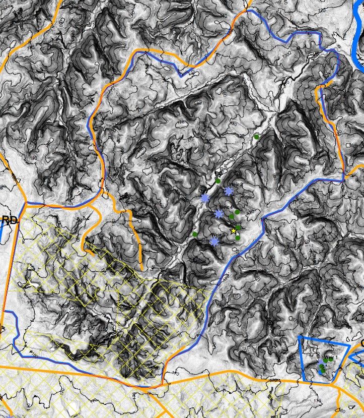
Holcombe's Branch is a 650-ha watershed that encompasses the three experimental catchments in which continuous rainfall and runoff data were collected from the late 1940s to the early 1960s. Georeferenced soil sampling of the Holcombe's Branch watershed, including downslope fans and terraces, and upland interfluves and hillslopes, will significantly improve estimates of SOC dynamics from eroded hillslope to alluvial terrace.
Three of the four historic Calhoun experimental catchments are located in Research Area 3 (the fourth is in Research Area 1). These are being re- and up-instrumented based on precipitation and runoff gauging from the 1940s to 1960s. The catchments were severely eroded and gullied and have been reforested over the last half century. The archived hydrologic records were stored in the Coweeta Hydrologic Laboratory data vault since 1962. Contemporary hydrologic responses of the catchments will be compared with those that are historic. The three experimental catchments reside within the much larger Holcombe's Branch, a tributary of the Tyger River. The Holcombe's Branch basin will be used to examine the erosion's interactions with soil carbon gains and losses.
Holcombe's Branch is central to developing the theme of erosion-induced carbon dynamics. Soil organic matter (SOM) is destabilized and greatly diminished by accelerated decomposition when CZs are cutover and soils plowed. However, not all agricultural losses of SOM from a degraded soil derive from oxidation and return to the atmosphere as CO2. Lateral fluxes of eroded SOM can be deposited downslope or downstream and subsequently buried in alluvial fans and terraces along streams and rivers, i.e. in low lying, moist environments with potentially low decomposition rates (Billings et al., 2010). Whether a significant fraction of eroded SOM is preserved in these depositional sites has significant consequences for estimates of global carbon cycling (Harden et al., 1999; Billings et al., 2010; van Oost et al., 2007). Furthermore, the rates at which eroded upland sites are re-accumulating contemporary SOC may be accelerated relative to pre-disturbance rates since erosion will have exposed iron- and aluminum-oxide rich B horizons that may have considerable C stabilization potential.
-
Overview Maps
CCZO R3

See full size (in new tab/window)
-
Dynamic Map
To fully zoom into a small area, you may need to visit the "Map" button and uncheck "Terrain" view.
-
Data
Calhoun Critical Zone Observatory - Soil Moisture - Saturated Hydraulic Conductivity (Ksat) (2017)
2 components • Calhoun CZO Research Area 2, Calhoun CZO Research Area 3 • Soil Science / Pedology • Ryland, Rachel; Markewitz, Daniel; Sutter, LoriCalhoun CZO - Soil Survey - Soil Texture (2014-2015)
3 components • Calhoun CZO Research Area 3, Calhoun CZO Research Area 4 • Soil Science / Pedology • Heine, PaulCalhoun CZO - Streamflow / Discharge (2014-2017)
1 components • Calhoun Experimental Forest and Eco-hydrology Experiments, Calhoun CZO Research Area 3 • Hydrology • Mallard, John McDevittCalhoun CZO - Vegetation - Litterfall (2014-2017)
1 components • Calhoun CZO Research Area 1, Calhoun CZO Research Area 2, Calhoun CZO Research Area 3, Calhoun CZO Research Area 4, Calhoun CZO Research Area 5 • Biology / Ecology • Cook, Charles W.; O'Neill, K. P.; Richter, Daniel deB.Calhoun CZO - Geomorphology - Gully Boundaries (2015)
1 components • Calhoun CZO Research Area 3 • Geomorphology, Hydrology • Leonardo V. Noto; Yannis Dialynas; Satish BastolaCalhoun CZO - Soil Texture - Argillic Horizon (2016-2017)
1 components • Calhoun CZO Research Area 2, Calhoun CZO Research Area 3, Calhoun CZO Research Area 4 • Soil Science / Pedology • Ryland, Rachel C.
Explore Further

