Harpold et al., 2015
Laser vision: lidar as a transformative tool to advance critical zone science
Harpold, A. A., Marshall, J. A., Lyon, S. W., Barnhart, T. B., Fisher, B. A., Donovan, M., Brubaker, K. M., Crosby, C. J., Glenn, N. F., Glennie, C. L., Kirchner, P. B., Lam, N., Mankoff, K. D., McCreight, J. L., Molotch, N. P., Musselman, K. N., Pelletier, J., Russo, T., Sangireddy, H., Sjöberg, Y., Swetnam, T., and West, N. (2015)
Hydrol. Earth Syst. Sci., 19, 2881-2897 Cross-CZO National
-

Boulder, Catalina-Jemez, INVESTIGATOR
-

National, Boulder, Eel, Sierra, INVESTIGATOR
-

Boulder, Sierra, INVESTIGATOR
-

Reynolds, INVESTIGATOR
-

Catalina-Jemez, INVESTIGATOR
-

Shale Hills, INVESTIGATOR, COLLABORATOR
-

Catalina-Jemez, INVESTIGATOR
-

Sierra, COLLABORATOR
-

Shale Hills, INVESTIGATOR
Abstract
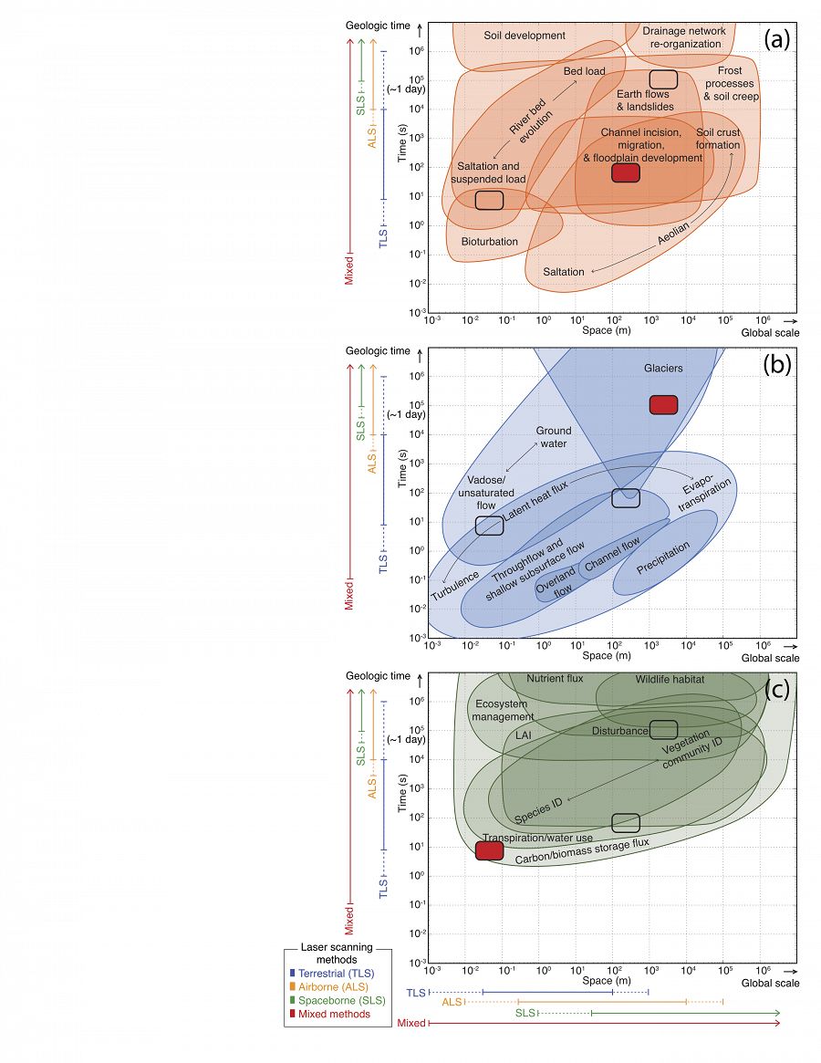
Important CZ processes graphed as a function of time versus space for geomorphology (a), hydrology (b), and ecology (c). The spatial and temporal scales that lidar is currently addressing are shown as colored bars, with dotted bars indicating increasing resolutions and larger extents available in the next 5 years. Overlapping spatiotemporal scales that encompass the example questions are also noted with red boxes.
Observation and quantification of the Earth’s surface is undergoing a revolutionary change due to the increased spatial resolution and extent afforded by light detection and ranging (lidar) technology. As a consequence, lidar-derived information has led to fundamental discoveries within the individual disciplines of geomorphology, hydrology, and ecology. These disciplines form the cornerstones of Critical Zone (CZ) science, where researchers study how interactions among the geosphere, hydrosphere, and biosphere shape and maintain the “zone of life”, which extends from the top of unweathered bedrock to the top of the vegetation canopy. Fundamental to CZ science is the development of transdisciplinary theories and tools that transcend individual disciplines and inform other’s work, capture new levels of complexity, and create new intellectual outcomes and spaces. Researchers are just beginning to utilize lidar datasets to answer synergistic, transdisciplinary questions in CZ science, such as how CZ processes co-evolve over long-time scales and interact over shorter time scales to create thresholds, shifts in states and fluxes of water, energy, and carbon. The objective of this review is to elucidate the transformative potential of lidar for CZ science to simultaneously allow for quantification of topographic, vegetative, and hydrological processes. A review of 147 peer-reviewed studies utilizing lidar highlights the lag in the application of lidar for CZ studies as 38% of the studies were focused in geomorphology, 18% in hydrology, 32% in ecology, and the remaining 12% had an interdisciplinary focus. A handful of exemplar transdisciplinary studies demonstrate that well-integrated lidar observations can lead to fundamental advances in CZ science, such as identification of feedbacks between hydrological and ecological processes over hillslope scales and the synergistic co-evolution of landscape-scale CZ structure due to interactions amongst carbon, energy, and water cycles. We propose that using lidar to its full potential will require numerous advances across CZ applications, including new and more powerful open-source processing tools, exploiting new lidar acquisition technologies, and improved integration with physically-based models and complementary in situ and remote-sensing observations. We provide a five-year vision that advocates for the expanded use of lidar datasets and highlights subsequent potential to advance the state of CZ science.
Citation
Harpold, A. A., Marshall, J. A., Lyon, S. W., Barnhart, T. B., Fisher, B. A., Donovan, M., Brubaker, K. M., Crosby, C. J., Glenn, N. F., Glennie, C. L., Kirchner, P. B., Lam, N., Mankoff, K. D., McCreight, J. L., Molotch, N. P., Musselman, K. N., Pelletier, J., Russo, T., Sangireddy, H., Sjöberg, Y., Swetnam, T., and West, N. (2015): Laser vision: lidar as a transformative tool to advance critical zone science. Hydrol. Earth Syst. Sci., 19, 2881-2897. DOI: doi:10.5194/hess-19-2881-2015
 This Paper/Book acknowledges NSF CZO grant support.
Explore Further
