Reynolds Creek Experimental Watershed
The Reynolds Creek CZO is located in the Reynolds Creek Experimental Watershed (RCEW) in the Owyhee Range in southwest Idaho. RCEW is 239 square km and encompasses a wide range of environments typical to the intermountain region of the western USA.
239 km2 Area
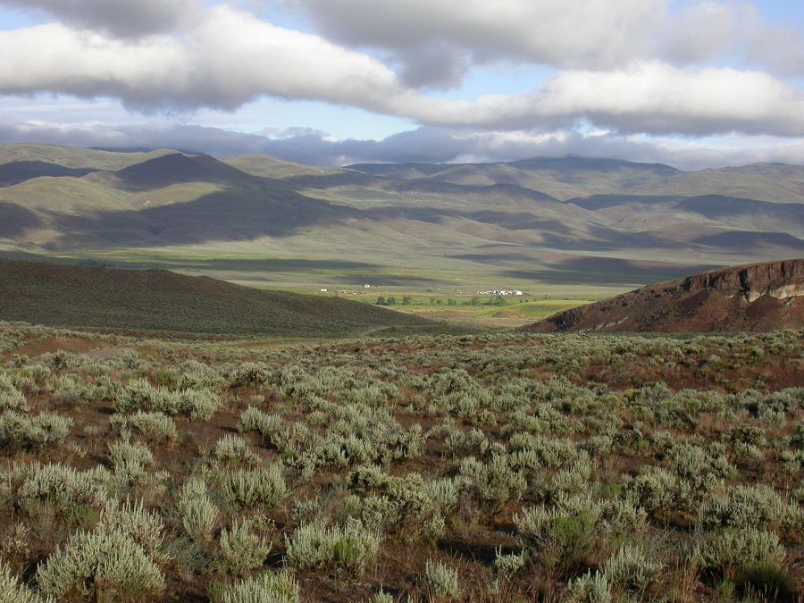
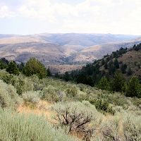
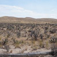
Reynolds Creek Experimental Watershed from the Breaks
Areas within Reynolds Creek Experimental Watershed
-
Setting & Research
Reynolds Creek Experimental Watershed (RCEW) is an ideal location for the establishment of a CZO for the following reasons: 1) it is physically diverse and has a wide range of climate conditions, 2) it supports a preexisting, long-term, spatially extensive data collection and 3) it is the site of land management practice evaluation. These points are expanded on below.
Environment
Located in southwestern Idaho, the RCEW encompasses a wide range of ecohydrological environments typical of the intermountain region of the western USA. An extensive description of the RCEW environment can be found in Seyfried et al., (2001). The environmental variability is driven by the nearly 1000 m elevation range and variable geology. Precipitation in the RCEW is not strictly a function of elevation, but generally increases with elevation from less than 250 mm/y to greater than 1100 mm/y while mean annual temperature decreases about 5°C. Rain is the dominant form of precipitation in the RCEW, with snow dominating in the highest elevations. Corresponding vegetation types include sagebrush steppe in the lower elevations, transitioning to mountain sagebrush, western juniper, aspen and coniferous forest (Figure 1).
Soil carbon (SC) varies widely within the RCEW, both in amount and type. For example, at one, high elevation site under aspen and affected by snow drifting, the depth-weighted average (to 150 cm) SOC content is 20.3 g C/kg with no measureable SIC. (Soil pH is about 6.3 at all depths). This is contrasted with a depth-weighted average SOC content of 5.0 g C/kg at a low elevation, much drier site under sagebrush. At the low elevation site, however, 39.8 g C/kg of SIC was measured, so that considerably more total SC is stored at the low elevation site. There are strong vertical gradients of SOC in both profiles, and no SIC was detected above 76 cm at the low elevation site. This “flipping” of the predominant SC form with elevation, or more precisely, with soil environment, is evident in the detailed, watershed specific soil survey that was conducted at the watershed (Stephenson, 1977).
Scientific Infrastructure
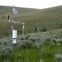
The existing scientific infrastructure is a key advantage for the RCEW site as a CZO. Most CZO sites require substantial funding to produce a hydro-meteorological network that falls short of that available currently at the RCEW. This network is critical because it forms the basis for understanding how the soil environment varies over time and space. Detailed descriptions of the RCEW and published data can be found in Hanson, 2001; Hanson et al., 2001; Marks, 2001; Seyfried et al., 2001a; Seyfried et al., 2001b; Seyfried et al., 2001c; Seyfried et al., 2001d; Slaughter et al., 2001; Nayak et al., 2010; Chauvin et al., 2011; Reba et al., 2011; Seyfried et al., 2011 (see also ftp.nwrc.ars.gov for data).
Historic database
The existing, publically available hydroclimatic data are long-term and spatially extensive. The long-term nature of the data research can be conducted in the context of the climate at different locations and how it is changing. An increase in temperature (1-2°C), reduction of snow and temporal shift of streamflow with no change in total precipitation or soil water storage have been documented at the RCEW (Nayak et al., 2010; Seyfried et al., 2011). The spatially extensive nature of the data is critical given the now understood horizontal, as well as vertical, variability of the climate within the RCEW. These data are not collected on a regular grid, but spaced with higher density in areas of steeper environmental gradients and at specific special study sites.
Soil Environment
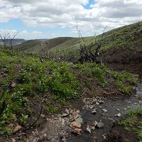
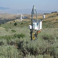
Characterization of the soil environment, as opposed to the climate, is central to the CZO. The original soil water and temperature data collection network, which extends back more than 30 years, has been dramatically expanded in the past ten years to include robust, well calibrated (Seyfried et al., 2005) soil water and temperature sensors. This kind of data is necessary for confirming the accuracy of the SC models used to calculate SC dynamics across the landscape (e.g., RCEW). Note that data collection is spread throughout the RCEW and also concentrated in specific research sites. For example, data collected at Johnston Draw is intended to elucidate topographic influences (Figure 2), while that at Upper Sheep Creek is focused on differential snow distribution. Other sites (not shown) are oriented toward grazing effects in the low elevations.
Eddy Covariance
Determination of present day carbon balance, in conjunction with the water balance will be critical. The existing 5 EC instruments have been used for hydrological research to date (Marks et al., 2008; Reba, 2009; Flerchinger, 2010; Flerchinger et al., 2012; Reba et al., 2012a; Reba et al., 2012b) but carbon flux has been monitored throughout, providing a potentially powerful starting point. The instruments will be redeployed to reflect a shift in research emphasis to include carbon fluxes at drier, SIC dominated sites.
LiDAR
Reynolds Creek has LiDAR (point clouds and processed bare earth rasters) for the entire experimental watershed, with a point cloud density of ~5 pts/m2. The dataset is adequate for estimation of aboveground biomass estimates for large shrubs and trees but are not entirely sufficient to resolve sagebrush steppe aboveground biomass estimates.
Fire and the Prescribed Fire Program
Fire frequency and extent are increasing in the Western US with changes in climate (Westerling et al., 2006) and vegetation (introduced species such as Bromus tectorum (cheatgrass) (Allen et al., 2011). Use of prescribed fire as a management practice has emerged as a tool to control fuel loads (McIver et al., 2010); the NWRC has undertaken a prescribed fire management program in cooperation with the Bureau of Land Management (BLM). The Northwest Watershed Research Center (NWRC) selects sites, conducts experiments and monitors and evaluates fire effects, while the BLM assists in site selection and conducts the fires. The primary ecohydrological criteria for site selection is that precipitation be sufficient such that invasive species such as cheatgrass, and yellow star thistle do not expand as a result of the fire. To date, three fires (2002, 2004 and 2007) have been conducted in the RCEW. The next fire is scheduled for 2013. The temporal sequence of past fires and the ability to participate in the planning of future fires provides a rare opportunity for research into the effects of fire on SC.
Watershed Management
In general, the management and ownership of the RCEW lands are typical of much of the western US, which is to say that the RCEW is a “working” as opposed to a pristine, watershed. Most of the land in the watershed (77%) is owned by either the state or federal government, and, in this case, managed by the Bureau of Land Management (BLM). The remaining, privately held land is managed by local ranchers, primarily four families that live in or adjacent to the watershed and derive their livelihood from cattle ranching. In addition to cattle grazing, a small part of the valley is used to raise hay and there is some timber harvesting. The mission of the NWRC compliments the objectives of the CZO program: “To provide knowledge and technology for management of semi-arid rangeland watersheds; to quantitatively describe the hydrologic processes and interactive influences of climate, soils, vegetation, topography, and management on rangeland systems; to develop information, simulation models, and tools that can be used by action agencies and producers in determining optimum management strategies; and to maintain long-term databases for scientific applications.” Much of the success of the unit has been through cooperative research with academic institutions. In fact, the RCEW is intended to provide a spring-board for complimentary research. Accommodation, with wifi and rudimentary lab space is provided for visitors, which typically log about 100 visitor-hours each year.
-
Data
Johnston Draw - Climate, Meteorology, Hydropedologic Properties (2003-2014)
2 components • Reynolds Creek Experimental Watershed • Biology / Ecology, Climatology / Meteorology, Hydrology, Soil Science / Pedology • Godsey, Sarah E.; Marks, Danny G.; Kormos, Patrick R.; Seyfried, Mark S.; Enslin, Clarissa L.; McNamara, James P.; Link, Timothy E.Johnston Draw - Soil Survey - Predicting Soil Thickness (2014-2016)
1 components • Reynolds Creek Experimental Watershed • Soil Science / Pedology • Patton, N.R.; Lohse, K.A.; Godsey, S.E.; Seyfried, M.S.; Crosby, B.T.Johnston Draw - Soil Biogeochemistry, Soil Survey, Topographic Carbon Storage - soil organic carbon, bulk density (2014-2016)
2 components • Reynolds Creek Experimental Watershed • Biogeochemistry, Soil Science / Pedology • Patton, N.R.; Lohse, K.A.; Godsey, S.E.; Parsons, S.B.; Seyfried, M.S.National - Flux Tower - AmeriFlux Network data (2007-2018)
14 components • Boulder Creek Watershed, Jemez River Basin, Reynolds Creek Experimental Watershed, Susquehanna Shale Hills Critical Zone Observatory, San Joaquin Experimental Range (210-520 m elevation), Soaproot Saddle (1000-1500 m elevation), Short Hair (2670 m elevation) • Climatology / Meteorology • Boulder Creek Critical Zone Observatory; Catalina-Jemez Critical Zone Observatory; Reynolds Creek Critical Zone Observatory; Shale Hills Critical Zone Observatory; Southern Sierra Critical Zone ObservatoryNational - LiDAR, Land Cover, GIS/Map Data - OpenTopography (2010-2017)
18 components • Boulder Creek Watershed, Eel River Watershed, Jemez River Basin, Reynolds Creek Experimental Watershed, Susquehanna Shale Hills Critical Zone Observatory, Northeastern Puerto Rico and the Luquillo Mountains, Sangamon River Basin, Clear Creek Watershed, Calhoun Critical Zone Observatory, Providence Creek Headwater Catchments (1660 - 2115 m elevation) • Geomorphology, GIS / Remote Sensing, Hydrology, Biology / Ecology • National Center for Airborne Laser Mapping; Boulder Creek Critical Zone Observatory; Calhoun Critical Zone Observatory; University of Arizona; University of California Merced; Valles Caldera National Preserve; Bandelier National Monument; National Park Service; Jemez River Basin and Santa Catalina Mountains Critical Zone Observatory; Luquillo Critical Zone Observatory; Reynolds Creek CZO; Eel River CZO; Shale Hills CZONational - Streamflow / Discharge - USGS and USDA Data Resources (1985-2017)
22 components • Boulder Creek Watershed, Santa Catalina Mountains, Jemez River Basin, Reynolds Creek Experimental Watershed, Susquehanna Shale Hills Critical Zone Observatory, Northeastern Puerto Rico and the Luquillo Mountains, Clear Creek Watershed, Sangamon River Basin, Calhoun Critical Zone Observatory, Providence Creek Headwater Catchments (1660 - 2115 m elevation) • Hydrology • USGS National Water Information SystemReynolds Creek - Digital Elevation Model (DEM), Land Cover, LiDAR (2007)
1 components • Reynolds Creek Experimental Watershed • GIS / Remote Sensing • Boise State University; Boise Aerospace Center Laboratory; Nancy GlennReynolds Creek - GIS/Map Data (2014)
3 components • Reynolds Creek Experimental Watershed • All Disciplines • USDA-ARS; Idaho State University; Boise State UniversityReynolds Creek - Land Cover, LiDAR, Vegetation - Biomass Estimate of Sagebrush (2012)
1 components • Reynolds Creek Experimental Watershed • Biology / Ecology, GIS / Remote Sensing, Modeling / Computational Science • Li, Aihua; Glenn, Nancy F; Olsoy, Peter J; Mitchell, Jessica J; Shrestha, RupeshReynolds Creek - LiDAR, Snow Depth - Snow-Depth (2009)
1 components • Reynolds Creek Experimental Watershed • GIS / Remote Sensing, Hydrology • Boise State University; Boise Aerospace Center Laboratory; Nancy GlennReynolds Creek - Meteorology - approximate date range (1981-2009)
1 components • Reynolds Creek Experimental Watershed • Climatology / Meteorology • USDA-ARS Northwest Watershed Research CenterReynolds Creek - Nutrient Fluxes, Climate, Flux Tower - Eddy Covariance (2014-2018)
1 components • Reynolds Creek Experimental Watershed • Climatology / Meteorology, Biogeochemistry • Fellows, A.W.; Flerchinger, G.N.; Seyfried, M.S.; Lohse, K.A.Reynolds Creek - Precipitation (1962-2014)
2 components • Reynolds Creek Experimental Watershed • Climatology / Meteorology • USDA ARS Northwest Watershed Research CenterReynolds Creek - Soil Moisture (1977-2011)
1 components • Reynolds Creek Experimental Watershed • Biology / Ecology, Soil Science / Pedology • Mark S. Seyfried; Gerald N. Flerchinger; Clatyon L. Hanson; Mark D. Murdock; Steven S. Van VactorReynolds Creek - Soil Temperature (1977-2014)
1 components • Reynolds Creek Experimental Watershed • Biogeochemistry, Climatology / Meteorology, Soil Science / Pedology • USDA ARS Northwest Watershed Research CenterReynolds Creek - Streamflow / Discharge (1963-2014)
1 components • Reynolds Creek Experimental Watershed • Climatology / Meteorology, Hydrology • USDA ARS Northwest Watershed Research CenterReynolds Creek - Geology, Soil Survey, Vegetation, GIS/Map Data (1960-1970)
7 components • Reynolds Creek Experimental Watershed • Biology / Ecology, Geology / Chronology, Soil Science / Pedology • Gordon R. StephensonReynolds Creek - Soil Biogeochemistry - Soil Organic Carbon (2014-2017)
1 components • Reynolds Creek Experimental Watershed • Biogeochemistry, Soil Science / Pedology • Will, R.M.; Benner, S.; Glenn, N.F.; Pierce, J.; Lohse, K.A.; Patton, N.; Spaete, L.P.; Stanbery, C.Reynolds Creek Experimental Watershed - Climate, GIS/Map Data - Temperature, Humidity, Precip Amount & Phase (1983-2014)
1 components • Reynolds Creek Experimental Watershed • Climatology / Meteorology • P. Kormos; D. Marks; M. Seyfried; S. Havens; A. Hendrick; K. Lohse; M. Maserik; A. FloresReynolds Creek Experimental Watershed - Digital Elevation Model (DEM), GIS/Map Data, LiDAR (2015)
1 components • Reynolds Creek Experimental Watershed • GIS / Remote Sensing • NCALM; Kathleen LohseReynolds Creek Experimental Watershed - Hydropedologic Properties, Soil Water, Soil Survey (2014-2018)
1 components • Reynolds Creek Experimental Watershed • Soil Science / Pedology • Murdock, M.D.; Huber, D.P.; Seyfried, M.S.; Patton, N.R.; Lohse, K.A.Reynolds Creek Experimental Watershed - LiDAR, Digital Elevation Model (DEM) - DEM (2014)
1 components • Reynolds Creek Experimental Watershed • GIS / Remote Sensing • Nayani Ilangakoon; Nancy F. Glenn; Lucas P. Spaete; Hamid Dashti; Aihua Li
Explore Further
