Rempe & Dietrich, 2014
A bottom-up control on fresh-bedrock topography under landscapes
Rempe, D.M., Dietrich, W.D. (2014)
Proceedings of the National Academy of Sciences 111 (18): 6576-6581
-

Eel, INVESTIGATOR, COLLABORATOR
-

Eel, INVESTIGATOR
Abstract
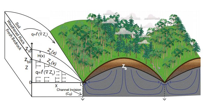
Conceptual model showing the elevation of fresh bedrock, Zb, under ridge and valley topography with a thin soil mantle overlying a weathered bedrock zone that extends to Zb. Channel incision, at the rate Co, drives hillslope erosion and drainage of fresh bedrock (flow paths illustrated with blue arrows). (Left) The model framework and assumptions. At the ridgetop (x=0), the surface elevation is Zs0 and the fresh-bedrock elevation is Zb0. Groundwater flux, qw, is horizontal and proportional to the water table gradient, ∇Zb. Soil transport, qs, is proportional to the surface slope, ∇Zs. All soil and water leaves the hillslope at L where the hillslope meets the channel. At steady state, the rate of channel incision (Co) is equal to the uplift rate such that the ground surface, Zs and surface of the fresh bedrock, Zb, are stationary.
The depth to unweathered bedrock beneath landscapes influences subsurface runoff paths, erosional processes, moisture availability to biota, and water flux to the atmosphere. Here we propose a quantitative model to predict the vertical extent of weathered rock underlying soil-mantled hillslopes. We hypothesize that once fresh bedrock, saturated with nearly stagnant fluid, is advected into the near surface through uplift and erosion, channel incision produces a lateral head gradient within the fresh bedrock inducing drainage toward the channel. Drainage of the fresh bedrock causes weathering through drying and permits the introduction of atmospheric and biotically controlled acids and oxidants such that the boundary between weathered and unweathered bedrock is set by the uppermost elevation of undrained fresh bedrock, Zb. The slow drainage of fresh bedrock exerts a “bottom up” control on the advance of the weathering front. The thickness of the weathered zone is calculated as the difference between the predicted topographic surface profile (driven by erosion) and the predicted groundwater profile (driven by drainage of fresh bedrock). For the steady-state, soil-mantled case, a coupled analytical solution arises in which both profiles are driven by channel incision. The model predicts a thickening of the weathered zone upslope and, consequently, a progressive upslope increase in the residence time of bedrock in the weathered zone. Two nondimensional numbers corresponding to the mean hillslope gradient and mean groundwater-table gradient emerge and their ratio defines the proportion of the hillslope relief that is unweathered. Field data from three field sites are consistent with model predictions.
Citation
Rempe, D.M., Dietrich, W.D. (2014): A bottom-up control on fresh-bedrock topography under landscapes. Proceedings of the National Academy of Sciences 111 (18): 6576-6581. DOI: 10.1073/pnas.1404763111
 This Paper/Book acknowledges NSF CZO grant support.
Explore Further
