Calhoun Long-Term Soil-Ecosystem Plots and Reference Areas
The Calhoun LTSE has 16 permanent plots installed on the site of two former cotton fields planted to loblolly pine (P. taeda) in the winter of 1956-1957. From 1962 to present, the soil has been sampled to a depth of 60 cm approximately every 5 years. In 2007, 8 of the 16 plots were logged to initiate a new phase in the long-term experiment. Plot studies in the Calhoun CZO also include reference hardwoods, secondary pine, hay, and cultivated crops. Source: D. Richter, 2001.
180 - 190 m Elev
16 °C Temp
1250 mm Precip
Parent Field Area:
Calhoun CZO Research Area 1 ▲
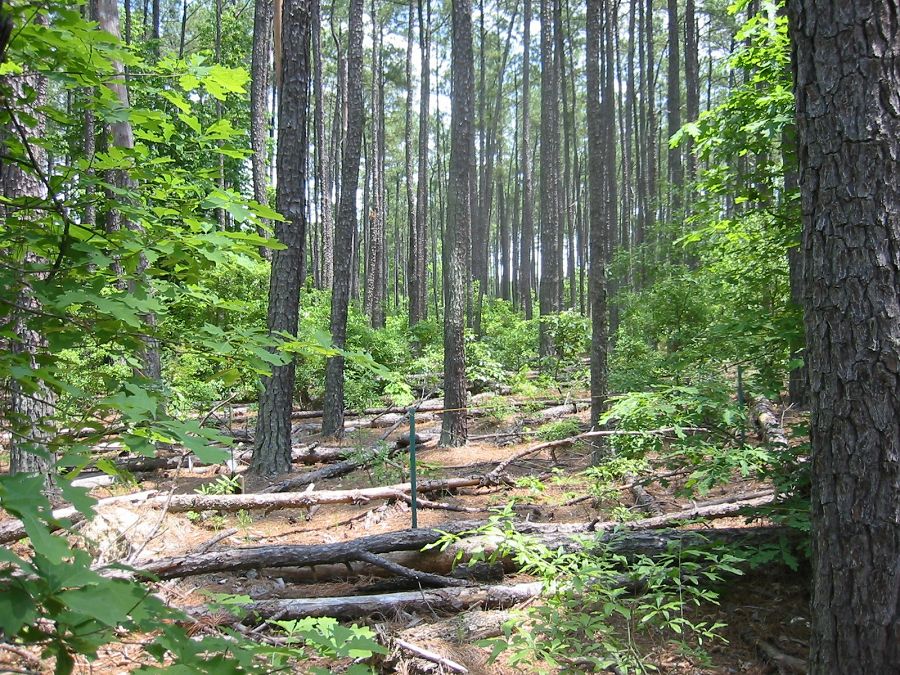
View through one of the 16 permanent plots at the Calhoun LTSE showing the loblolly pine overstory and hardwood understory. June 2004. Photo: Jason Jackson.
Lithology
unconsolidated materials, igneous-felsic intrusive, meta-igneous
Soil Order
Ultisol
Land Use
agricultural land, forest land
-
Setting & Research
The Calhoun Experimental Forest is located in Sumter National Forest near Union, SC. Annual precipitation averages 1272 mm and mean annual temperature averages 15.7 C. The site is characterized by gentle slopes (<3%) composed of Cataula series soil (fine, kaolinitic, thermic oxyaquic Kanhapludults).
The Calhoun LTSE in the Southern Carolina Piedmont, USA, was initiated in 1957 on old cotton fields by US Forest Service scientists. Vegetation and soil in the 16 0.1-ha plots have been resampled with nearly all samples archived on eight occasions (1962, 1968, 1972, 1977, 1982, 1990, 1997, 2005, 2010). The Calhoun study demonstrates like few others the dynamics of belowground ecological and geochemical processes and properties over a fifty year time scale. Results from the 16 permanent plots are supplemented by land-use history plots, also called reference areas with hardwoods, secondary pine, hay, and cultivated crops. The study also demonstrates how contemporary ecosystem dynamics are strongly controlled by historic land use impacts (the legacies of cotton cultivation between 1800 and 1955) and multi-millennial evolution of the natural ecosystem. In May 2007, half of the 16 permanent plots were clear-cut and are being regenerated with pine, all to better examine human impacts on decadal changes in soils and ecosystems. The Calhoun Experimental Forest has become a globally-significant experiment not only of management effects, but of natural recovery processes as well. Calhoun researchers invite collaborations with other scientists, land managers and users, teachers, writers, and students.

Three generations of Calhoun LTSE researchers, L-R: Carol Wells, Dan Richter, and Dan Markewitz. Calhoun soils have been sampled about every 5 years since 1962. The soils are archived at Duke University.

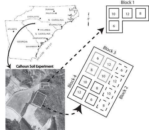
Experimental layout of sixteen 0.1 hectare field plots at the Calhoun LTSE originally based on testing the effects of tree spacing vs yield. The plots have been resampled on 10 occasions since 1957, when the old cotton fields were planted with loblolly pine seedlings.
Three generations of Calhoun LTSE researchers, L-R: Carol Wells, Dan Richter, and Dan Markewitz. Calhoun soils have been sampled about every 5 years since 1962. The soils are archived at Duke University.
Experimental layout of sixteen 0.1 hectare field plots at the Calhoun LTSE originally based on testing the effects of tree spacing vs yield. The plots have been resampled on 10 occasions since 1957, when the old cotton fields were planted with loblolly pine seedlings.
-
Overview Maps
The Calhoun Long-term Soil Ecosytem Experiment
Map showing location of the Calhoun LTSE permanent plots. Vegetation and soil in the 16 0.1-ha plots have been re-sampled on eight occasions (1962, 1968, 1972, 1977, 1982, 1990, 1997, 2005, 2010). Soil samples are archived at Duke University, Durham, NC.
See full size (in new tab/window)
-
Dynamic Map
To fully zoom into a small area, you may need to visit the "Map" button and uncheck "Terrain" view.
-
Data
Calhoun 70m deep well - Soil Geochemistry (2010)
1 components • Calhoun Long-Term Soil-Ecosystem Plots and Reference Areas • Soil Science / Pedology, Geochemistry / Mineralogy • Bacon, Allan R; Richter, Daniel deB.; Bierman, Paul R.; Rood, Dylan H.Calhoun CZO - LiDAR - LiDAR Leaf-Off Survey (2016)
1 components • Calhoun CZO Research Area 1, Calhoun CZO Research Area 4, Calhoun Experimental Forest and Eco-hydrology Experiments, Calhoun Long-Term Soil-Ecosystem Plots and Reference Areas • GIS / Remote Sensing • National Center for Airborne Laser MappingCalhoun CZO - LiDAR - LiDAR features for the Calhoun CZO forest plots (2015)
1 components • Calhoun Experimental Forest and Eco-hydrology Experiments, Calhoun Long-Term Soil-Ecosystem Plots and Reference Areas • GIS / Remote Sensing • Majasalmi, TittaCalhoun CZO - LiDAR - Hyperspectral and LiDAR Survey (2014)
1 components • Calhoun CZO Research Area 1, Calhoun CZO Research Area 4, Calhoun Experimental Forest and Eco-hydrology Experiments, Calhoun Long-Term Soil-Ecosystem Plots and Reference Areas • GIS / Remote Sensing • National Center for Airborne Laser MappingCalhoun CZO - Soil Geochemistry - Soil organic matter transformations (2015)
1 components • Calhoun Long-Term Soil-Ecosystem Plots and Reference Areas • Biogeochemistry, Biology / Ecology, Soil Science / Pedology • Min, K.; Flournoy, R.; Heroneme, C.; Barger, K.; Lehmeier, C.A.; Heine, P.; Richter, Daniel deB.; Billings, S.A.Calhoun CZO - Soil Geochemistry - Mössbauer spectroscopy (2015)
1 components • Calhoun Long-Term Soil-Ecosystem Plots and Reference Areas • Biogeochemistry, Soil Science / Pedology • Thompson, Aaron; Richter, Daniel deB.; Wilmoth, Jared; Barcellos, DiegoCalhoun CZO - Vegetation - Tree Survey (2014-2017)
1 components • Calhoun Experimental Forest and Eco-hydrology Experiments, Calhoun Long-Term Soil-Ecosystem Plots and Reference Areas • Biology / Ecology • Cook, Charles W.; Brecheisen, Z.; Richter, Daniel deB.Calhoun CZO - Soil Mineralogy (2014-2015)
1 components • Calhoun Long-Term Soil-Ecosystem Plots and Reference Areas • Soil Science / Pedology • Austin, Jason C.Calhoun CZO Research Area 1 - Flux Tower - Young Pine Forest (2016-2017)
4 components • Calhoun Long-Term Soil-Ecosystem Plots and Reference Areas, Calhoun CZO Research Area 1 • Climatology / Meteorology • Yao Tang; Jingfeng WangCalhoun Experimental Forest, SC - GIS/Map Data, Photographic Imagery - 1933 aerial imagery composite (1933)
2 components • Calhoun Experimental Forest and Eco-hydrology Experiments, Calhoun Long-Term Soil-Ecosystem Plots and Reference Areas • GIS / Remote Sensing • Brecheisen, Zachary S.; Cook, Charles W.; Harmon, M.A.Calhoun Long Term Soil Experiment - Soil Gas (1992-1996)
1 components • Calhoun Long-Term Soil-Ecosystem Plots and Reference Areas • Soil Science / Pedology, Biogeochemistry • Markewitz, Daniel; Richter, Daniel deB.Calhoun Long-Term Soil Experiment - Soil Geochemistry - 70-m deep borehole (2010)
1 components • Calhoun Long-Term Soil-Ecosystem Plots and Reference Areas • Biogeochemistry, Geochemistry / Mineralogy, Soil Science / Pedology • Bacon, A.R.; Richter, Daniel deB.Calhoun Long-Term Soil Experiment - Soil Moisture (1991-1995)
1 components • Calhoun Long-Term Soil-Ecosystem Plots and Reference Areas • Soil Science / Pedology, Hydrology • Markewitz, D.; Richter, Daniel deB.Calhoun Long-Term Soil Experiment - Soil Survey - Hydraulic Conductivity (2011)
1 components • Calhoun Long-Term Soil-Ecosystem Plots and Reference Areas • Soil Science / Pedology, Hydrology • Brewington, M. Lance; Richter, Daniel deB.Calhoun Long-Term Soil Experiment - Soil Water Chemistry (1991-1994)
1 components • Calhoun Long-Term Soil-Ecosystem Plots and Reference Areas • Soil Science / Pedology, Water Chemistry • Markewitz, Daniel; Richter, Daniel deB.Union County, SC - Land Use History - Agriculture Census (1950)
1 components • Calhoun Long-Term Soil-Ecosystem Plots and Reference Areas • Social Science • Giesen, James C.
Explore Further
