Calhoun Experimental Forest and Eco-hydrology Experiments
Three historic Calhoun experimental catchments are being re- and up-instrumented based on precipitation and runoff gauging from the 1940s to 1960s. The catchments were severely eroded and gullied and have been reforested over the last half century. The archived hydrologic records were stored in the Coweeta Hydrologic Laboratory data vault since 1962. Contemporary hydrologic responses of the catchments will be compared with those that are historic. The three experimental catchments reside within the much larger Holcombe's Branch, a tributary of the Tyger River. The Holcombe's Branch basin will be used to examine the erosion's interactions with soil carbon gains and losses.
134 - 157 m Elev
16 °C Temp
1250 mm Precip
Parent Field Area:
Calhoun Critical Zone Observatory ▲
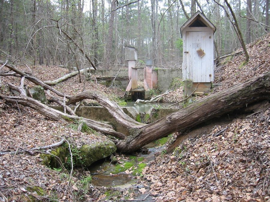
A soon-to-be upgraded watershed research site at the Calhoun CZO in the Southeast Piedmont.
Lithology
unconsolidated materials, igneous-felsic intrusive, meta-igneous
Soil Order
Ultisol
Land Use
agricultural land, forest land
-
Setting & Research
The three experimental catchments are in the headwaters of the Holcombe's Branch a tributary of the Tyger River near Sedalia, SC. Precipitation and streamflow gauges are being installed at the beginning of the CZO project.
-
Dynamic Map
To fully zoom into a small area, you may need to visit the "Map" button and uncheck "Terrain" view.
-
Data
Calhoun CZO - LiDAR - LiDAR Leaf-Off Survey (2016)
1 components • Calhoun CZO Research Area 1, Calhoun CZO Research Area 4, Calhoun Experimental Forest and Eco-hydrology Experiments, Calhoun Long-Term Soil-Ecosystem Plots and Reference Areas • GIS / Remote Sensing • National Center for Airborne Laser MappingCalhoun CZO - LiDAR - LiDAR features for the Calhoun CZO forest plots (2015)
1 components • Calhoun Experimental Forest and Eco-hydrology Experiments, Calhoun Long-Term Soil-Ecosystem Plots and Reference Areas • GIS / Remote Sensing • Majasalmi, TittaCalhoun CZO - LiDAR - Hyperspectral and LiDAR Survey (2014)
1 components • Calhoun CZO Research Area 1, Calhoun CZO Research Area 4, Calhoun Experimental Forest and Eco-hydrology Experiments, Calhoun Long-Term Soil-Ecosystem Plots and Reference Areas • GIS / Remote Sensing • National Center for Airborne Laser MappingCalhoun CZO - Stream Water Chemistry (2014-2018)
2 components • Calhoun Experimental Forest and Eco-hydrology Experiments • Water Chemistry • Foroughi, M.; Cook, Charles W.; Heine, P.; Richter, Daniel deB.Calhoun CZO - Streamflow / Discharge (2014-2017)
1 components • Calhoun Experimental Forest and Eco-hydrology Experiments, Calhoun CZO Research Area 3 • Hydrology • Mallard, John McDevittCalhoun CZO - Vegetation - Leaf Area Index (2014)
1 components • Calhoun CZO Research Area 1, Calhoun CZO Research Area 4, Calhoun Experimental Forest and Eco-hydrology Experiments • Biology / Ecology • Cook, Charles W.Calhoun CZO - Vegetation - Tree Survey (2014-2017)
1 components • Calhoun Experimental Forest and Eco-hydrology Experiments, Calhoun Long-Term Soil-Ecosystem Plots and Reference Areas • Biology / Ecology • Cook, Charles W.; Brecheisen, Z.; Richter, Daniel deB.Calhoun Experimental Forest, SC - GIS/Map Data, Photographic Imagery - 1933 aerial imagery composite (1933)
2 components • Calhoun Experimental Forest and Eco-hydrology Experiments, Calhoun Long-Term Soil-Ecosystem Plots and Reference Areas • GIS / Remote Sensing • Brecheisen, Zachary S.; Cook, Charles W.; Harmon, M.A.Calhoun Experimental Forest, SC - Streamflow / Discharge, Precipitation (1949-1962)
1 components • Calhoun Experimental Forest and Eco-hydrology Experiments • Hydrology, Climatology / Meteorology • Jingfeng Wang; Yawen Shen; Sabina ShahnazCalhoun Experimental Forest, SC - Land Use History, Photographic Imagery (1932-1987)
1 components • Calhoun Experimental Forest and Eco-hydrology Experiments • Outreach / Education Research, Social Science • Nelson, Donald R.; O'Neill, Katherine P.; Coughlan, Michael R.; Lonneman, Michael C.; Meyers, Zachary; U.S. Department of Agriculture; Forest ServiceCalhoun Experimental Watershed 4 - Streamflow / Discharge, Electrical Conductivity (2015)
2 components • Calhoun Experimental Forest and Eco-hydrology Experiments • Hydrology • Mallard, John; McGlynn, BrianCalhoun Experimental Watershed 4 - Soil Electrical Resistivity (2015)
1 components • Calhoun Experimental Forest and Eco-hydrology Experiments • Geophysics • Daniel MarkewitzCalhoun Experimental Watersheds 2, 3, 4 - Soil Moisture, Soil Redox Potential (2014-2015)
1 components • Calhoun Experimental Forest and Eco-hydrology Experiments • Biogeochemistry, Soil Science / Pedology • Caitlin Hodges; Daniel Markewitz; Aaron ThompsonResearch area 3 - Groundwater Depth - 5 minute resolution (2014-2015)
1 components • Calhoun Experimental Forest and Eco-hydrology Experiments • Hydrology • Mallard, John; McGlynn, Brian -
Partner Organizations
Explore Further
