Calhoun CZO Research Area 4
One of four historic Calhoun experimental catchments, which were instrumented with precipitation and runoff gauges from the 1940s to 1960s. The catchment was severely eroded and gullied and has been reforested over the last half century. The archived hydrologic records and photographs have been stored in the Coweeta Hydrologic Laboratory data vault since 1962. Contemporary hydrologic responses of the catchments will be compared with the historical data.
0.42 km2 Area
Parent Field Area:
Calhoun Critical Zone Observatory ▲
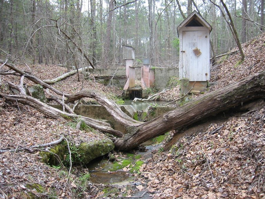
Remains of the old weir at the historic watershed 1 research site in the Calhoun Experimental Forest.
-
Setting & Research
Research area 4 at the Calhoun CZO includes the first of the historical weirs in the Calhoun Experimental Forest, located in an area of eroded abandoned agricultural land known as watershed 1. This weir was instrumented from the 1940s to the 1960s. Complementing this eroded watershed, which is now covered with pine forest, is a nearby watershed that was likely not cultivated and has seen little erosion. This watershed has been covered with mature hardwood forest since at least 1933 (as seen in historic USFS photos).

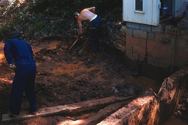
Brown and Arthur cleaning mud out of Weir 1 ponding basin, May 2, 1955.
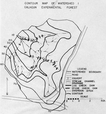
Contour map of Watershed 1, Calhoun Exp. Forest. Showing check dams and stream diversion works, 1/28/1958.

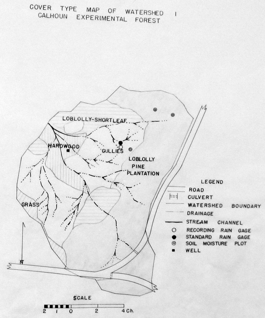
Cover Type Map of Watershed 1, Calhoun Exp. Forest showing instrument location, 1/28/1958.
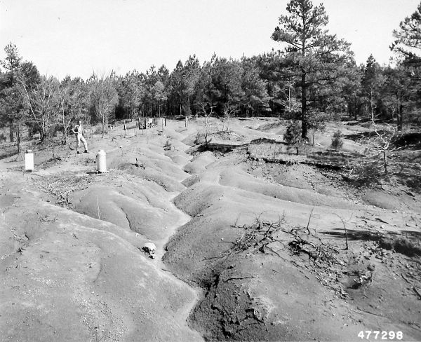
Gullied land above weir 1. Original caption: View from Camera point A before treatment. Taken on ladder. Lens about 12 feet about ground. RRG [recording rain gage] #9 in left foreground. Soil moisture plot 2 in rear, CEF. Photo: 4/1/1954 by L.J.M.
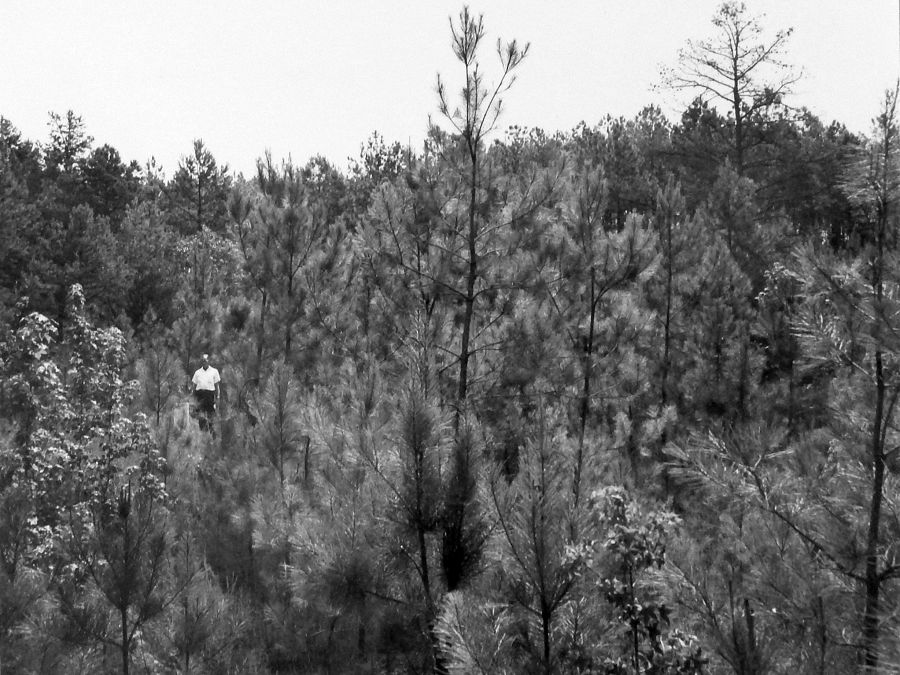
Planted loblolly pine coming through the serecia. Camera point A. August 1959, Photo: L.J.M.
View taken from Camera Point A. Taken from Ladder with lens 12 above ground level. Picture made in 1962 after stablilization with Lespedeza and Loblolly pine. Photo: L.J.M.

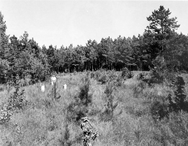
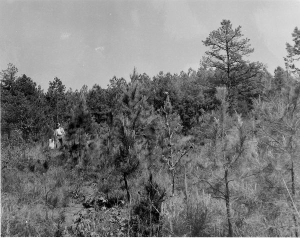
View from Camera point A eight years after treatment and seven years after pines were planted. September 1963. Photo: Douglass.
Brown and Arthur cleaning mud out of Weir 1 ponding basin, May 2, 1955.
Contour map of Watershed 1, Calhoun Exp. Forest. Showing check dams and stream diversion works, 1/28/1958.
Cover Type Map of Watershed 1, Calhoun Exp. Forest showing instrument location, 1/28/1958.
Gullied land above weir 1. Original caption: View from Camera point A before treatment. Taken on ladder. Lens about 12 feet about ground. RRG [recording rain gage] #9 in left foreground. Soil moisture plot 2 in rear, CEF. Photo: 4/1/1954 by L.J.M.
Planted loblolly pine coming through the serecia. Camera point A. August 1959, Photo: L.J.M.
View taken from Camera Point A. Taken from Ladder with lens 12 above ground level. Picture made in 1962 after stablilization with Lespedeza and Loblolly pine. Photo: L.J.M.
View from Camera point A eight years after treatment and seven years after pines were planted. September 1963. Photo: Douglass.
-
Overview Maps
CCZO R4

See full size (in new tab/window)
-
Dynamic Map
To fully zoom into a small area, you may need to visit the "Map" button and uncheck "Terrain" view.
-
Data
Calhoun Critical Zone Observatory - Soil Moisture - Hydroprobe (2016-2018)
1 components • Calhoun CZO Research Area 1, Calhoun CZO Research Area 4, Calhoun CZO Research Area 7 • Hydrology, Biogeochemistry, Soil Science / Pedology • Austin, Jason C.; Brecheisen, Zachary S.; Cook, Charles W.; Heine, Paul R.; Richter, Daniel deB.Calhoun CZO - LiDAR - LiDAR Leaf-Off Survey (2016)
1 components • Calhoun CZO Research Area 1, Calhoun CZO Research Area 4, Calhoun Experimental Forest and Eco-hydrology Experiments, Calhoun Long-Term Soil-Ecosystem Plots and Reference Areas • GIS / Remote Sensing • National Center for Airborne Laser MappingCalhoun CZO - LiDAR - Hyperspectral and LiDAR Survey (2014)
1 components • Calhoun CZO Research Area 1, Calhoun CZO Research Area 4, Calhoun Experimental Forest and Eco-hydrology Experiments, Calhoun Long-Term Soil-Ecosystem Plots and Reference Areas • GIS / Remote Sensing • National Center for Airborne Laser MappingCalhoun CZO - Soil Survey - Soil Texture (2014-2015)
3 components • Calhoun CZO Research Area 3, Calhoun CZO Research Area 4 • Soil Science / Pedology • Heine, PaulCalhoun CZO - Vegetation - Litterfall (2014-2017)
1 components • Calhoun CZO Research Area 1, Calhoun CZO Research Area 2, Calhoun CZO Research Area 3, Calhoun CZO Research Area 4, Calhoun CZO Research Area 5 • Biology / Ecology • Cook, Charles W.; O'Neill, K. P.; Richter, Daniel deB.Calhoun CZO - Vegetation - Leaf Area Index (2014)
1 components • Calhoun CZO Research Area 1, Calhoun CZO Research Area 4, Calhoun Experimental Forest and Eco-hydrology Experiments • Biology / Ecology • Cook, Charles W.Calhoun CZO - Soil Porosity, Soil Invertebrates (2015-2017)
2 components • Calhoun CZO Research Area 1, Calhoun CZO Research Area 4, Calhoun CZO Research Area 7 • Soil Science / Pedology, Biology / Ecology • Brecheisen, Zachary S..; Callaham, M.A.; Heine, P.R.; Cook, Charles W.; Richter, Daniel deB.Calhoun CZO - Soil Texture - Argillic Horizon (2016-2017)
1 components • Calhoun CZO Research Area 2, Calhoun CZO Research Area 3, Calhoun CZO Research Area 4 • Soil Science / Pedology • Ryland, Rachel C.Calhoun CZO - Soil Texture (2015-2016)
1 components • Calhoun CZO Research Area 1, Calhoun CZO Research Area 4, Calhoun CZO Research Area 7 • Soil Science / Pedology • Heine, Paul RResearch areas 1, 4, 7 - Soil Gas (2015-2017)
2 components • Calhoun CZO Research Area 1, Calhoun CZO Research Area 4, Calhoun CZO Research Area 7 • Biogeochemistry, Soil Science / Pedology • Brecheisen, Z. S.; Cook, Charles W.; Richter, Daniel deB. -
Partner Organizations


Explore Further
