Morris Run
Morris Run is one of three CRB-CZO field areas used as long-term reference watersheds in the Stroud Preserve Reforested Riparian Buffer Project.
0.149 km2 Area
79 - 116 m Elev
12 °C Temp
1145 mm Precip
Parent Field Area:
Riparian Buffer Experiment @ Stroud Preserve/Georgia Farm ▲
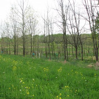
The reforested riparian buffer at Morris Run.
Lithology
metasediments
Biome
deciduous forest
Land Use
rangeland
-
Setting & Research
As part of the Stroud Preserve Reforested Riparian Buffer Project, alll but a few hectares of the Morris Run watershed were maintained in contoured strips under a crop rotation program established by the U.S.D.A. Natural Resources Conservation Service. The primary crops were maize, soybeans, and hay (alfalfa). Records were kept of all fertilizer applications, and of crop yields.
-
Dynamic Map
To fully zoom into a small area, you may need to visit the "Map" button and uncheck "Terrain" view.
-
Data
Christina River Basin - Stream Water Temperatures (2007-2014)
8 components • Christina River Basin, Halfway Run, Mine Hill Run, Morris Run, White Clay Creek @ SWRC, Forest Endmember: Spring Brook, Riparian Buffer Experiment @ Stroud Preserve/Georgia Farm • Water Chemistry • Sweeney, B.; Funk, D.; Newbold, J. D.; Kaplan, L. A.; Damiano, S. G.; Kline, F.; West, H. -
Partner Organizations
-
Associated Files
Mitigation of Nonpoint Pollution by a Riparian Forest Buffer in an Agricultural Watershed of the Mid-Atlantic Piedmont
(2 MB pdf)
Stroud Preserve Watersheds National Monitoring Project Final Report
Explore Further


