Holbrook et al., 2019
Links between physical and chemical weathering inferred from a 65-m-deep borehole through Earth’s critical zone
Holbrook, W. Steven, Virginia Marcon, Allan R. Bacon, Susan L. Brantley, Bradley J. Carr, Brady A. Flinchum, Daniel D. Richter, & Clifford S. Riebe (2019)
Scientific Reports 9: Article number 4495
-

Boulder, Calhoun, Eel, Reynolds, Sierra, COLLABORATOR
-

Shale Hills, GRAD STUDENT
-

Calhoun, INVESTIGATOR
-

National, Eel, Luquillo, Shale Hills, INVESTIGATOR, COLLABORATOR
-

Sierra, COLLABORATOR, GRAD STUDENT
-

Calhoun, INVESTIGATOR
-

Sierra, INVESTIGATOR
Abstract
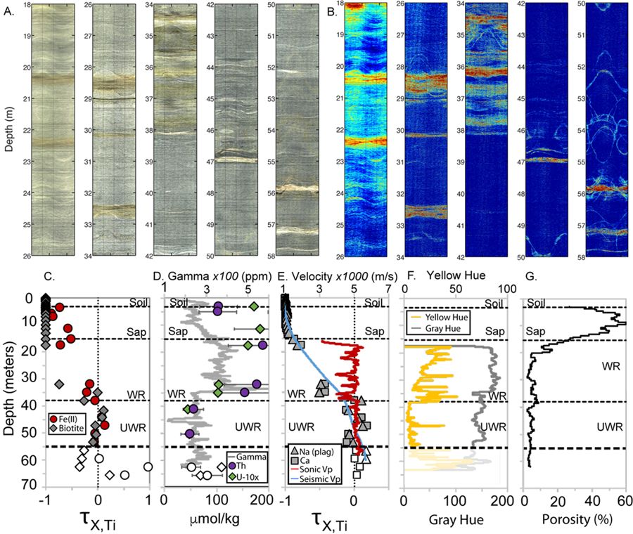
Figure 1. Downhole borehole images, geochemistry, and geophysics. Optical borehole imager view of the borehole wall (A) and yellow hue, defined as (R + G)/2-B (B). Inclined planar features such as fractures appear as sinusoids on these unrolled 360° images of the borehole wall. Warm colors in (B represent higher levels of yellow and brown; cooler colors represent gray. Above 55 m depth, yellow/brown versus gray hues generally indicate weathered versus unweathered minerals, respectively; below 55 m, a different rock exists and yellow colors do not necessarily indicate weathering. Downhole geochemical and geophysical data demarcate the onset of weathering around 38 m depth (C–G), which corresponds with visual changes in A and B.
As bedrock weathers to regolith – defined here as weathered rock, saprolite, and soil – porosity grows, guides fluid flow, and liberates nutrients from minerals. Though vital to terrestrial life, the processes that transform bedrock into soil are poorly understood, especially in deep regolith, where direct observations are difficult. A 65-m-deep borehole in the Calhoun Critical Zone Observatory, South Carolina, provides unusual access to a complete weathering profile in an Appalachian granitoid. Co-located geophysical and geochemical datasets in the borehole show a remarkably consistent picture of linked chemical and physical weathering processes, acting over a 38-m-thick regolith divided into three layers: soil; porous, highly weathered saprolite; and weathered, fractured bedrock. The data document that major minerals (plagioclase and biotite) commence to weather at 38 m depth, 20 m below the base of saprolite, in deep, weathered rock where physical, chemical and optical properties abruptly change. The transition from saprolite to weathered bedrock is more gradational, over a depth range of 11–18 m. Chemical weathering increases steadily upward in the weathered bedrock, with intervals of more intense weathering along fractures, documenting the combined influence of time, reactive fluid transport, and the opening of fractures as rock is exhumed and transformed near Earth’s surface.
Citation
Holbrook, W. Steven, Virginia Marcon, Allan R. Bacon, Susan L. Brantley, Bradley J. Carr, Brady A. Flinchum, Daniel D. Richter, & Clifford S. Riebe (2019): Links between physical and chemical weathering inferred from a 65-m-deep borehole through Earth’s critical zone. Scientific Reports 9: Article number 4495. DOI: 10.1038/s41598-019-40819-9
 This Paper/Book acknowledges NSF CZO grant support.
Explore Further
