Edgeworth et al., 2015
Diachronous beginnings of the Anthropocene: The lower bounding surface of anthropogenic deposits
Edgeworth, M., D.deB. Richter, C. Waters, P. Haff, C. Neal, S.J. Price (2015)
The Anthropocene Review 2 (1): 33-58
-
Calhoun, INVESTIGATOR
Abstract
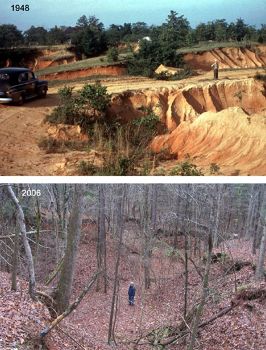
Photographs taken in 1948 and 2006 of the agriculturally eroded landscape of the Calhoun Critical Zone Observatory, South Carolina, USA. From the late 18th to early 20th century, Boundary A consisted of the base of cultivated soils of cotton fields. Continued crop production led to ever more severe soil erosion. By the early 20th century, farm fields were commonly cut by gullies and even ravines, with sediments transported by gully and stream channel networks, to be deposited downstream in river floodplains, behind dams, on deltas and estuaries. By the late 20th century, second-growth forests had established themselves on much of the eroded landscape. The archaeosphere and its lower boundary have been and continue to be transformed by these developments. Source: Photos by USDA Forest Service and James et al. (2006).
Across a large proportion of Earth’s ice-free land surfaces, a solid-phase stratigraphic boundary marks the division between humanly modified ground and natural geological deposits. At its clearest, the division takes the form of an abrupt surface at the base of deposits variously called ‘artificial ground’, ‘anthropogenic ground’ or ‘archaeological stratigraphy’ – which together comprise a distinctive part of the geosphere called the ‘archaeosphere’. In other cases the bounding surface is more diffuse, gradational or mixed, due to action of non-human agencies and anthropedogenic forcings. It is alternately conformable and unconformable. Layers above typically contain artificial features, structures, artifacts and other material traces of human activity, in contrast to their relative absence in layers below. A fundamental characteristic of the boundary is that it is diachronous, still being formed and renewed today. In examining the boundary, this paper asks – does it reflect the diachronous onset and development of the Anthropocene itself?
Citation
Edgeworth, M., D.deB. Richter, C. Waters, P. Haff, C. Neal, S.J. Price (2015): Diachronous beginnings of the Anthropocene: The lower bounding surface of anthropogenic deposits. The Anthropocene Review 2 (1): 33-58. DOI: 10.1177/2053019614565394
 This Paper/Book acknowledges NSF CZO grant support.
Explore Further


