What is a Critical Zone?

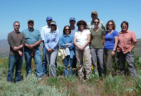
What is a Critical Zone Observatory?…………………………………… The Reynolds Creek Experimental Watershed southwest of Boise, a recently designated "Critical Zone Observatory" (CZO), is contributing to long-term scientific studies relevant to much of the Intermountain West and the Great Basin. Several BLM members from the Idaho State Office Resources Branch and Owyhee Field Office learned this recently on one of their monthly "First Friday" tours…
|
Reynolds Creek was just selected as a CZO by the National Science Foundation. "We don't do much external marketing, but you should know that this experimental watershed is one of just ten CZOs in the country… and the only one on BLM-managed public land," stated Agricultural Research Service (ARS) Researcher Fred Pierson, with much enthusiasm.
With long-standing ARS researchers Mark Seyfried and Fred Pierson as their field guides, they took no shortcut as they led the group into the upper elevations of the watershed to discuss their ongoing research. Large-scale water monitoring along weirs of all sizes and elevation/aspect research driven by juniper control and prescribed fire have been long-standing topics.
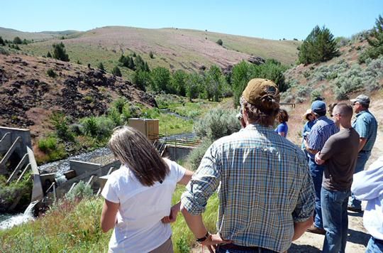
The group gathers at Tollgate Weir. Installed in 1966, it is the oldest and largest weir in the watershed.
"This area was likely chosen because of the unique circumstances," said Seyfried as the group gathered in a meadow high above the valley. "The scientific infrastructure in place in the 93-square-mile watershed includes numerous stations collecting climate, precipitation, stream-flow, snow and soil data under a wide variety of conditions. The core data collection network dates back to the 1960s, providing a tremendous amount of long-term data."
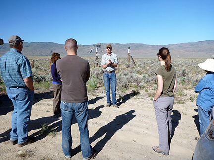
Mark Seyfried, Soil Scientist with the ARS, at one of the low elevation weather station sites and weir location that collects overland flow runoff and sediment.
A CZO is an environmental laboratory which provides a platform for research that functions at the catchment/watershed scale focused on the interconnected chemical, physical and biological processes shaping Earth's surface. Specifically, the Reynolds Creek CZO will address the grand challenges of improving prediction of soil carbon (C) storage and flux from the pedon to landscape scale. Some of the questions scientists hope to answer include:
-How do climate, vegetation, topography, and lithology and regolith properties control and modulate the distribution of soil carbon?
-How do landscape patterns of climate, regolith, and vegetation control soil moisture, evapotranspiration, and streamflow and losses of C as gas and stream export? How do these patterns control and modulate C gains?
-How do land management practices such as prescribed fire and grazing affect carbon storage and the processes governing it?
-How might the distribution of inorganic and organic carbon change with a changing climate and management actions?
-What are the characteristic scales of spatial and temporal variability of soil carbon, and what are the hydrologic, geomorphic and ecosystem variables that correlate with that scale?
Soil carbon is the largest terrestrial C store but remains a large source of uncertainty in global climate models due to scaling and process understanding. The Reynolds Creek CZO is focused on the quantification of soil carbon and the critical zone processes governing it.
In the meantime, there is a great likelihood that someone in your office is reading or citing a scientific paper that includes research from the Reynolds Creek Experimental Watershed. It's time to make room on the shelf because, without doubt, we will see much to come in the future – but we will reserve that task for a rainy day as we have many more "First Fridays" left to explore on Idaho's BLM public lands.
For more information on CZOs, check out the following website: /national/infrastructure/observatories-1national/
By Gina Rone, soil scientist, BLM Idaho State Office
Reynolds Creek CZO
The group gathers at Tollgate Weir. Installed in 1966, it is the oldest and largest weir in the watershed.
Mark Seyfried, Soil Scientist with the ARS, at one of the low elevation weather station sites and weir location that collects overland flow runoff and sediment.
News Category:
Discipline Tags and CZOs
Biology / Ecology
Geochemistry / Mineralogy
Hydrology
Soil Science / Pedology
Reynolds
Explore Further
