Understanding Vegetation-Snow Interactions and Critical Zone Sensitivity to Climate Change
How sensitive is above ground biomass to snowpack loss?
Christopher J. Tennant, Idaho State University, tennchri@isu.edu
Overview
In the arid western U.S., seasonal stores of mountain snowpack play a key role in sustaining water sources for human and ecological systems. The expectation of warmer temperatures [IPCC, 2014], accelerated warming at high elevations [Rangwala and Miller, 2012], and the potential for increased precipitation [IPCC, 2014] will likely impact the amount, spatial distribution, and duration of seasonal snowpack in mountain landscapes [Tennant et al, 2015]. Warming-driven changes in the spatial distribution and temporal duration of mountain snowpack will likely cause shifts in vegetation and could influence vegetation-snowpack interactions in complex ways. Here, we propose to use LiDAR-derived “snow-covered” and “snow-free” elevation products from five Critical Zone Observatories (CZOs) to evaluate (1) at what spatial scales snow depth and above ground biomass (AGB) are mostly strongly coupled, (2) how this coupling varies between different CZOs/ecozones, and (3) how data resolution influences our appraisal of the sensitivity of AGB and snowpack to climate warming.
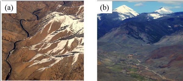
Figure 1: Topography, elevation, snowpack, and vegetation exhibit complex spatial arrangements. In some portions of the Critical Zone (a), vegetation and snow respond to aspect, while in others (b), elevation is the dominant control. Understanding the current spatial patterns and correlations between topography, snowpack and biomass is critical for predicting future responses.
Research Team
This proposal will utilize cross-CZO collaborations and includes the following researchers with expertise in cryosphere sciences, soils, mountain hydrology, and remote sensing. Dr. Adrian Harpold (UNR), Dr. Qunghua Guo (UC Merced), Dr. Kitty Lohse (ISU), Dr. Benjamin Crosby (ISU), Dr. Nancy Glenn (BSU), Dr. Danny Marks (USDA), and Dr. Sarah Godsey (ISU).
Figure 1: Topography, elevation, snowpack, and vegetation exhibit complex spatial arrangements. In some portions of the Critical Zone (a), vegetation and snow respond to aspect, while in others (b), elevation is the dominant control. Understanding the current spatial patterns and correlations between topography, snowpack and biomass is critical for predicting future responses.
equation
Figure 2: We hypothesize that (a) at finer scales of observation (LiDAR data), snow depth (black line) and above ground biomass (AGB, green) respond similarly with respect to aspect, while at coarser scales (model data, USGS DEM), their behaviors are better correlated with elevation.
News Category:
EDUCATION/OUTREACH |
OPPORTUNITIES
People Involved
CZO
-
Boulder, Catalina-Jemez, INVESTIGATOR
-
Reynolds, INVESTIGATOR
-
Reynolds, COLLABORATOR
-
National, Sierra, COLLABORATOR
Explore Further


