Preferential Flow
Hydrologic Flowpaths and Hydropedology
Vertical and lateral flowpaths provide a "short-circuit" for water flux in the shallow subsurface.
Model Category: Conceptual
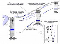
Image: Diagram of preferential flow both vertically (along macropores) and laterally (at soil horizons) which drives hydrologic variability in the shallow subsurface at Shale Hills (from Lin et al. 2006).
-
IML, Shale Hills, INVESTIGATOR
Hydrologic response in the Shale Hills catchment includes limited overland flow, yet streamflow is observed to rise quickly in response to rainfall. Through detailed observation of soil moisture distributed through the catchment, subsurface lateral flow is observed as the predominant mechanism for hydrologic behavior. This flow occurs along soil horizon boundaries and in macropores. Topographic convergence may concentrate lateral flow such that it returns to the surface at the base of a hillslope. The spatial pattern of soil depth and topographic convergence, along with lateral subsurface flow, drive the short-term hydrologic system at Shale Hills.
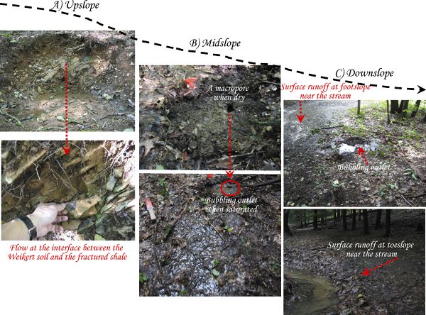
Photos of preferential flow (A) along soil-bedrock interface, (B) in macropores (here a rodent burrow), and (C) return flow at the toeslope. (from Lin, 2006).
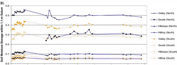
Overall, moisture patterns are stable over time across all soil types in the catchment, and soil moisture is more strongly dependent on topography than soil characteristics. Because of topographic effects, coupled with subsurface lateral flow pathways and slightly higher cumulative rainfall, the south-facing slope at Shale Hills is hydrologically more active than the north-facing slope. This is evident in reduced moisture storage in south-facing slopes. Determining the functional role of preferential flowpaths is an ongoing research task for SSHCZO researchers.
Photos of preferential flow (A) along soil-bedrock interface, (B) in macropores (here a rodent burrow), and (C) return flow at the toeslope. (from Lin, 2006).
Soil moisture storage along north- and south-facing slopes at Shale Hills. Lower storage on south-facing slopes).
Publications
2006
Soil moisture patterns in a forested catchment: A hydropedological perspective. Lin, H.S., Kogelmann, W., Walker, C., and Bruns, M.A. (2006): Geoderma 131:345-368.
2006
Temporal stability of soil moisture spatial pattern and subsurface preferential flow pathways in the Shale Hills Catchment. Lin, H.S. (2006): Vadose Zone Journal 5:317-340.
Explore Further


