Isotope Weathering
Isotopic Estimates of Weathering
Isotope geochemistry (Uranium, Thorium, Beryllium) offer estimates of weathering rates at Shale Hills.
Model Category: Conceptual
-

National, Eel, Luquillo, Shale Hills, INVESTIGATOR, COLLABORATOR
-

Shale Hills, INVESTIGATOR, COLLABORATOR
-

Shale Hills, INVESTIGATOR, COLLABORATOR
-

Shale Hills, INVESTIGATOR, COLLABORATOR
-

Shale Hills, INVESTIGATOR
SSHCZO researchers have developed models for geomorphology and weathering using isotopic tracers to determine rates of mass transport. Using meteoric 10Be isotopes, which are deposited atmospherically, West et al. (2011) found a maximum erosion rate on a north-facing slope of 19.4 ± 0.2 m/Myr.
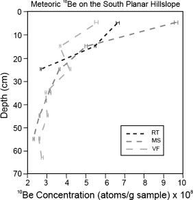
Depth profiles of 10Be concentrations for the three sample locations along the north-facing hillslope used to derive weathering loss rates (from West et al. 2011).
Ma et al. (2010) used (238U,234U, and 230Th) to determine rates of regolith production from bedrock, suggesting that bedrock is weathered at rates from 45 m/Myr to 17 m/Myr, with increasing regolith thickness from the ridge top to the valley floor.
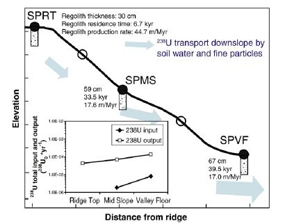
Regolith thickness, residence time, and production rate calculated for the north-facing hillslope. (inset) Total input and output of 238U for each profile along the 2D transect (from Ma et al. 2010).
Depth profiles of 10Be concentrations for the three sample locations along the north-facing hillslope used to derive weathering loss rates (from West et al. 2011).
Regolith thickness, residence time, and production rate calculated for the north-facing hillslope. (inset) Total input and output of 238U for each profile along the 2D transect (from Ma et al. 2010).
Publications
2011
Preliminary estimates of regolith generation and mobility in the Susquehanna Shale Hills Critical Zone Observatory, Pennsylvania, using meteoric 10Be. West, N., Kirby, E., Bierman, P., Rood, D., (2011): International Symposium on the Geochemistry of the Earth’s Surface, Boulder, CO, June, 2011
2010
Regolith production rates calculated with uranium-series isotopes at Susquehanna/Shale Hills Critical Zone Observatory. Ma, L., Chabaux, F., Pelt, E., Blaes, E., Jin, L., and Brantley, S.L. (2010): Earth and Planetary Science Letters vol 297, 211-225.
Explore Further
