Lewis et al., 2018
Integrating Unmanned Aerial Systems and LSPIV for Rapids, Cost-Effective Stream Gauging
Lewis, Q.W., Lindroth, E.M., and Rhoads, B.L. (2018)
Journal of Hydrology
-
IML, GRAD STUDENT
-

IML, INVESTIGATOR
Abstract
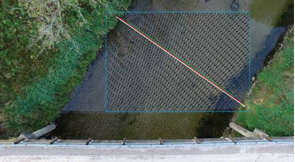
Surface velocity vectors (black arrows) within the region of interest (dotted blue line). The white, red, and green lines show the cross section measured for the LSPIV (endpoint to endpoint), Swoffer propeller (water edge to water edge), and ADCP (cannot measure to water’s edge), respectively.
Quantifying flow in rivers is fundamental to assessments of water supply, water quality, ecological conditions, hydrological responses to storm events, and geomorphological processes. Image-based surface velocity measurements have shown promise in extending the range of discharge conditions that can be measured in the field. The use of Unmanned Aerial Systems (UAS) in image-based measurements of surface velocities has the potential to expand applications of this method. Thus far, few investigations have assessed this potential by evaluating the accuracy and repeatability of discharge measurements using surface velocities obtained from UAS. This study uses large-scale particle image velocimetry (LSPIV) derived from videos captured by cameras on a UAS and a fixed tripod to obtain discharge measurements at ten different stream locations in Illinois, USA. Discharge values are compared to reference values measured by an acoustic Doppler current profiler, a propeller meter, and established stream gauges. The results demonstrate the effects of UAS flight height, camera steadiness and leveling accuracy, video sampling frequency, and LSPIV interrogation area size on surface velocities, and show that the mean difference between fixed and UAS cameras is less than 10%. Differences between LSPIV-derived and reference discharge values are generally less than 20%, not systematically low or high, and not related to site parameters like channel width or depth, indicating that results are relatively insensitive to camera setup and image processing parameters typically required of LSPIV. The results also show that standard velocity indices (between 0.85 and 0.9) recommended for converting surface velocities to depth-averaged velocities yield reasonable discharge estimates, but are best calibrated at specific sites. The study recommends a basic methodology for LSPIV discharge measurements using UAS that is rapid, cost-efficient, and does not require major preparatory work at a measurement location, pre- and post-processing of imagery, or extensive background in image analysis and PIV.
Citation
Lewis, Q.W., Lindroth, E.M., and Rhoads, B.L. (2018): Integrating Unmanned Aerial Systems and LSPIV for Rapids, Cost-Effective Stream Gauging. Journal of Hydrology. DOI: doi.org/10.1016/j.jhydrol.2018.03.008
Explore Further
