Elhakeem et al., 2018
Understanding saturated hydraulic conductivity under seasonal changes in climate and land use
Elhakeem, M., Papanicolaou, A.N., Wilson, C.G., Chang, Y.-J., Burras, L., Abban, B., Wysocki, D.A., and Wills, S. (2018)
Geoderma
-

IML, INVESTIGATOR
-

IML, INVESTIGATOR
-

IML, GRAD STUDENT
Abstract
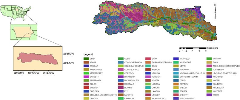
The study site: (a) The Clear Creek watershed, IA; (b) a soil map of the watershed from the Iowa County Soil Survey.
The goal of this study was to understand better the co-play of intrinsic soil properties and extrinsic factors of climate and management in the estimation of saturated hydraulic conductivity (Ksat) in intensively managed landscapes. For this purpose, a physically-based, modeling framework was developed using hydro-pedotransfer functions (PTFs) and watershed models integrated with Geographic Information System (GIS) modules. The integrated models were then used to develop Ksat maps for the Clear Creek, Iowa watershed and the state of Iowa. Four types of saturated hydraulic conductivity were considered, namely the baseline (Kb), the bare (Kbr), the effective with no-rain (Ke-nr) and the effective (Ke) in order to evaluate how management and seasonality affect Ksat spatiotemporal variability. Kb is dictated by soil texture and bulk density, whereas Kbr, Ke-nr, and Ke are driven by extrinsic factors, which vary on an event to seasonal time scale, such as vegetation cover, land use, management practices, and precipitation. Two seasons were selected to demonstrate Ksat dynamics in the Clear Creek watershed, IA and the state of Iowa; specifically, the months of October and April that corresponded to the before harvesting and before planting conditions, respectively.
Statistical analysis of the Clear Creek data showed that intrinsic soil properties incorporated in Kb do not reflect the degree of soil surface disturbance due to tillage and raindrop impact. Additionally, vegetation cover affected the infiltration rate. It was found that the use of Kb instead of Ke in water balance studies can lead to an overestimation of the amount of water infiltrated in agricultural watersheds by a factor of two. Therefore, we suggest herein that Ke is both the most dynamic and representative saturated hydraulic conductivity for intensively managed landscapes because it accounts for the contributions of land cover and management, local hydropedology and climate condition, which all affect the soil porosity and structure and hence, Ksat.
Citation
Elhakeem, M., Papanicolaou, A.N., Wilson, C.G., Chang, Y.-J., Burras, L., Abban, B., Wysocki, D.A., and Wills, S. (2018): Understanding saturated hydraulic conductivity under seasonal changes in climate and land use. Geoderma. DOI: 10.1016/j.geoderma.2017.11.011
 This Paper/Book acknowledges NSF CZO grant support.
Explore Further
