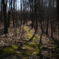
Hydropedology Research Group
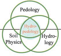
Image: A conceptual diagram showing the relationships of hydropedology to other related disciplines.
This group is tagged with:
-
Hydropedology Studies at the Shale Hills CZO: Hydropedology research being conducted at the Shale Hills CZO is multi-faced, cross-scale, and interdisciplinary. Two fundamental questions we seek to answer are:
(1) How do soil architecture and the distribution of soils over the landscape exert a first-order control on hydrologic processes (and associated biogeochemical and ecological dynamics) across spatio-temporal scales?
(2) How does landscape water (and the associated transport of energy, sediment, chemicals, and biomaterials by flowing water) influence soil genesis, evolution, variability, and functions?We focus on interactive hydrologic and pedologic processes at the pore, pedon, hillslope, and catchment scales.
The following several studies have been ongoing:
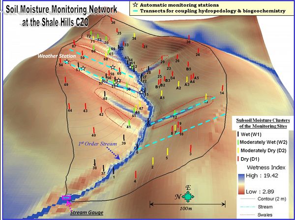
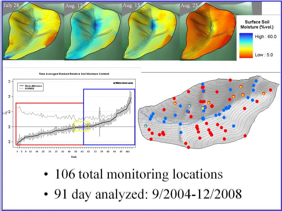
Soil Moisture Spatial-Temporal Patterns across Scales: A spatially dense network of soil hydrology monitoring has been implemented in the Shale Hills since 2004 (Fig. 1). This includes (1) a total of 106 sites (covering all soil types, topographic positions, and landform units in the catchment) where approximately weekly measurements of soil volumetric water content, matric potential, and water table are conducted manually from soil surface down to bedrock, and (2) a total of 20 stations where real-time soil moisture, matric potential, temperature, and water table are monitored automatically at 10-minutes interval. An example of soil moisture spatial pattern and its temporal stability is illustrated in Fig. 2. We continue to investigate the complex and dynamic controls of soil moisture spatial-temporal patterns (such as soil type, depth to bedrock, landform unit, topography, vegetation, and climate).
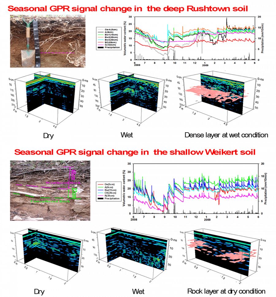
Subsurface Preferential Flow Network – Its Monitoring, Imaging, and Modeling: We use a suite of non-invasive imaging techniques (X-ray tomography, ground penetrating radar or GPR, and electromagnetic induction or EMI) in combination with real-time soil hydrologic monitoring to detect and model subsurface flow networks and their dynamics (Fig. 3). In particular, we use time-lapsed approaches to reveal complex subsurface architecture and its controls on water and chemical fluxes through various soils in different seasons (Fig. 4). A large geophysical database has been developed for the Shale Hills over the years.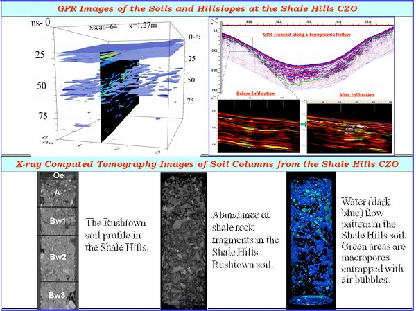
Defining and Delineating Hydropedological Functional Units: These are soil-landscapes units in the catchment that have similar soil properties and hydrologic functions. We plan to construct 3D stratified catchment to facilitate modeling and monitoring using these hydropedological functional units.
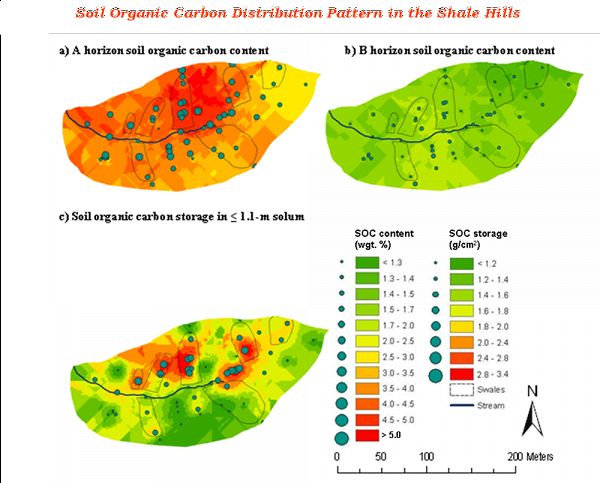
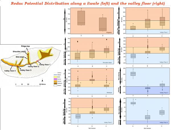
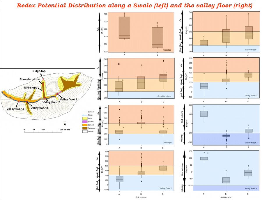
Coupling Hydropedology with Biogeochemistry with a Focus on Carbon: We are evaluating the coupling of hydropedological properties (e.g., soil type, depth, moisture content, water table, and redox dynamics) and biogeochemistry through the quantification of carbon dynamics. We have mapped out the spatial distribution of soil organic carbon throughout the catchment (Fig. 5). Soil pore waters from nested lysimeters in four hillslope transects (swales and planar hillslopes on both north and south sides of the catchment) in different landscape positions (ridge-top, mid-slope, and valley floor) are being continuously collected, along with bulk soil samples and stream and ground water samples, for analyzing dissolved organic carbon (DOC) and major cations and anions. Daily export of DOC from the stream and its flushing mechanism are also being investigated, as well as the role of redox and metals in stabilizing DOC to enhance carbon storage in the catchment soils (Fig. 6).
Contacts: Henry Lin (PI) henrylin@psu.edu
Collaborators: Jim Doolittle, Chris Duffy, Sue Brantley, Dave Eissenstat, Lixin Jin
Figure 1. Soil hydrologic monitoring network in Shale Hills.
Figure 2. Soil moisture spatial patterns and their temporal stability.
Figure 3. Non-invasive of the Shale Hills subsurface and its soils.
Figure 4. Repeated GPR scans in different times at the same location reveal the hydrologic dynamics in Shale Hills and the underlying subsurface structural control.
Figure 5. Organic carbon distribution pattern in the Shale Hills.
Figure 6. Redox potential spatial pattern along two transects (swale and valley floor).
-
Contacts
-
IML, Shale Hills, INVESTIGATOR
1 People

Cross-CZO INVESTIGATOR
.(JavaScript must be enabled to view this email address), 814-865-6726
Penn State
Hydropedology, Pedology, Soil Physics, Hydrology, Geophysics, Critical Zone Science
Alumni-Former

GRAD STUDENT
.(JavaScript must be enabled to view this email address)
Carbon in the soil environment

GRAD STUDENT
.(JavaScript must be enabled to view this email address)
Hydropedology and Ecology
INVESTIGATOR, PostDoc
Catchment and Hillslope Hydrology, Soil Physics, Ecohydrology

Cross-CZO GRAD STUDENT
.(JavaScript must be enabled to view this email address)
Hydropedology
-
-
Featured Publications
2011
Temporal Dynamics of Soil Moisture Spatial Variability in the Shale Hills Critical Zone Observatory. Takagi, K. and H.S. Lin. (2011): Vadose Zone Journal 10:832-842,
2008
Soil Moisture Response to Year-round Storm Events and Dominant Subsurface Flow Processes in a Steep Forested Catchment . Takagi, K., Lin, H.S. (2008): The 1st International Conference on Hydropedology, July 28-31, 2008, Penn State, University Park, PA.
2012
Changing controls of soil moisture spatial organization in the Shale Hills Catchment. Takagi, K. and Lin, H.S. (2012): Geoderma 173-174:289-302,


Explore Further
