ARCHIVED CONTENT: In December 2020, the CZO program was succeeded by the Critical Zone Collaborative Network (CZ Net)
×
Shale Hills LiDAR data available from OpenTopography
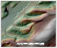
The Susquehanna Shale Hills LiDAR datasets (leaf-on and leaf-off) have been published on the OpenTopography website: Leaf Off Survey and Leaf On Survey.
News Category:
DATA

Explore Further
