Isotope Hydrology Research Group
A stable isotopic sampling network has been developed at the Susquehanna-Shale Hills Critical Zone Observatory to determine the δ2H (deuterium) and δ18O (oxygen-18) compositions of the hydrologic pools within the catchment.
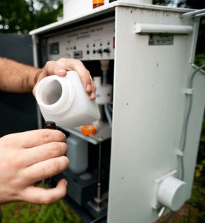
Image: Precipitation samples are collected from the Eigenbrodt NSA-181S for isotope analysis.
This group is tagged with:
-
Stable Isotope Network: A stable isotopic sampling network has been developed at the Susquehanna-Shale Hills Critical Zone Observatory to determine the δ2H (deuterium) and δ18O (oxygen-18) compositions of the hydrologic pools within the catchment. Deuterium and oxygen-18 are ideal tracers for hydrologic studies because they compose the water molecule itself and the concentration is only changed through phase changes or mixing of water parcels. SSHCZO has been approved as a node in the IAEA Global Network of Isotopes in Precipitation (GNIP) database. Some of the research questions include:
1) Are there spatial or temporal patterns with respect to the stable isotope composition of each hydrologic pool?
2) What is the continuous mean age of the system, and how does this mean age change over time?
3) What are the dominant flowpaths that water takes from precipitation to streamflow?
4) What effect does mobile and immobile flow have on the hydrologic system?
5) How does vegetation affect the hydrologic cycle?
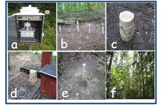
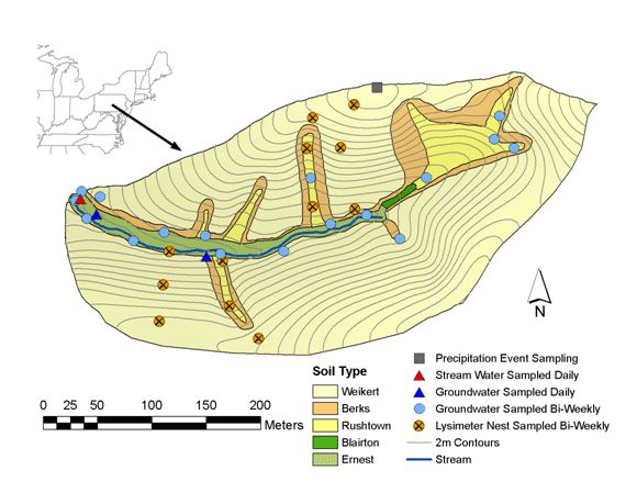
The stable isotope network covers all phases of the hydrologic cycle, including precipitation sampled on an event basis with an Eigenbrodt NSA-181S wet only collector (six-hour samples), soil water sampled approximately bi-weekly along four transects with suction-cup lysimeters, groundwater sampled daily at two wells with ISCO automatic samplers and weekly at 17 wells, vegetation sampled during the growing season, and stream water sampled daily with an ISCO automatic sampler. An example of the instruments used at the different sampling locations is shown in figure 1, and the location of the instruments is shown in figure 2. The comprehensive isotopic sampling of the catchment is possible because of the DLT-100 liquid water stable isotope analyzer from Los Gatos Research. The DLT-100, shown in figure 3, is an instrument utilizing off-axis integrated cavity output spectroscopy (laser-absorption spectroscopy) to determine absolute isotope abundances. The machine has a reproducibility of ± 0.8‰ for δ2H and ± 0.1‰ for δ18O, and the capability to run approximately 30 samples per day. From June 2008 through December 2011 more than 4,700 water samples were analyzed and processed.
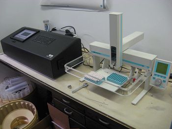 The goal of this research is to use the isotope network to understand the hydrologic functioning of the catchment. This includes determining the dominant flowpaths, when recharge occurs, where stream water comes from and the age and residence time of the water. A common visualization tool used by isotope hydrologists is the Local Meteoric Water Line, which plots precipitation δ2H values vs. δ18O values. Figure 4 shows SSHCZO’s LMWL compared to the Global Meteoric Water Line (GMWL) as well as the various hydrologic pools in the catchment. The LMWL closely matches the GMWL, which is expected for the climate of central Pennsylvania. It is clear from Figure 4 that the range of δ-values decreases from precipitation to soil water to stream water to groundwater. In general, the averages isotope composition of each pool is similar indicating mixing of water with depth.
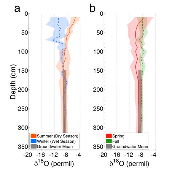
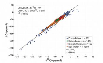 Figure 5 nicely shows seasonal damping of soil water isotopes with depth. Wet season (winter) isotope compositions are the most depleted and show the largest variation, especially in the upper soil layers. Conversely, dry season (summer) isotope compositions are the least depleted and have the lowest variation. The variation of each profile (shown as shaded regions) begins to explain the patterns of residence times within the soil matrix.
Preliminary groundwater investigations indicate groundwater recharge occurs primarily during the non-growing season with exceptions occurring during large events in the summer where hydrophobic soil surfaces promote vertical preferential flow through macropores. Interestingly, during large recharge events the groundwater will rise in the soil column and flush both the mobile and immobile deep soil water, transporting it towards the catchment outlet. Further results show stream water consists mainly of groundwater during the non-growing season and of summer precipitation during the growing season.
The stable isotope network, real time hydrologic network, real time soil moisture network, real time groundwater network and sap flow network are being used to quantitatively estimate the continuous mean age of the water in the catchment. The age model will incorporate transient hydrodynamics and determine the continuous mean age of the system from the moments of the tracer age distribution function. Preliminary results show the age of water within SSHCZO ranges from 4-9 months with a mean age of 6 months.
The ultimate goal of the isotope research is to determine the hydrologic functioning of the system so that it’s influence on regolith formation and development can be understood.
For more information about Isotope Hydrology at the Shale Hills CZO contact: Christopher Duffy: (PI); Evan Thomas (M.S. Student)
Figure 1. Examples of the instruments used to sample the isotopes at Shale Hills. a) Eigenbrodt NSA-181S wet only precipitation collector, b) suction cup lysimeter nest for weekly soil water, c) ISCO automatic sampler for daily groundwater, d) ISCO automatic sampler for daily stream water, e) groundwater wells sites for weekly sampling, and f) vegetation sites for synoptic isotope sampling.
Figure 2. Topographic map of Susquehanna-Shale Hills Critical Zone Observatory with stable isotope monitoring instruments.
Figure 3. DLT-100 liquid water stable isotope analyzer, with auto-injection unit, from Los Gatos Research.
Figure 4. Local Meteoric Water Line for SSHCZO.
Figure 5. Seasonal δ18O profiles for wet (winter) and dry (summer) seasons (a) and transitional seasons (spring and fall) (b) based on the three-year monitoring. One standard deviation is represented with shaded regions. Groundwater mean and one standard deviation is shown as grey bar for reference.
-
Contacts
-
Shale Hills, INVESTIGATOR
2 People

INVESTIGATOR
.(JavaScript must be enabled to view this email address)
Penn State
Stochastic and numerical modeling of groundwater flow and solute transport, modeling large-scale hydrologic systems.

INVESTIGATOR, COLLABORATOR
.(JavaScript must be enabled to view this email address)
low-temperature (bio)geochemistry, geochemistry, hydrogeology, isotope geology
Alumni-Former

GRAD STUDENT
Hydro-thermo-chemical modelling
-


Explore Further
