Hydroclimatology Research Group
The hydroclimatology team investigates the interactions of the subsurface-land-surface-atmosphere. A fully-coupled hydrologic-land-surface model is developed and tested on SSHO to study the subsurface-land-surface interaction.
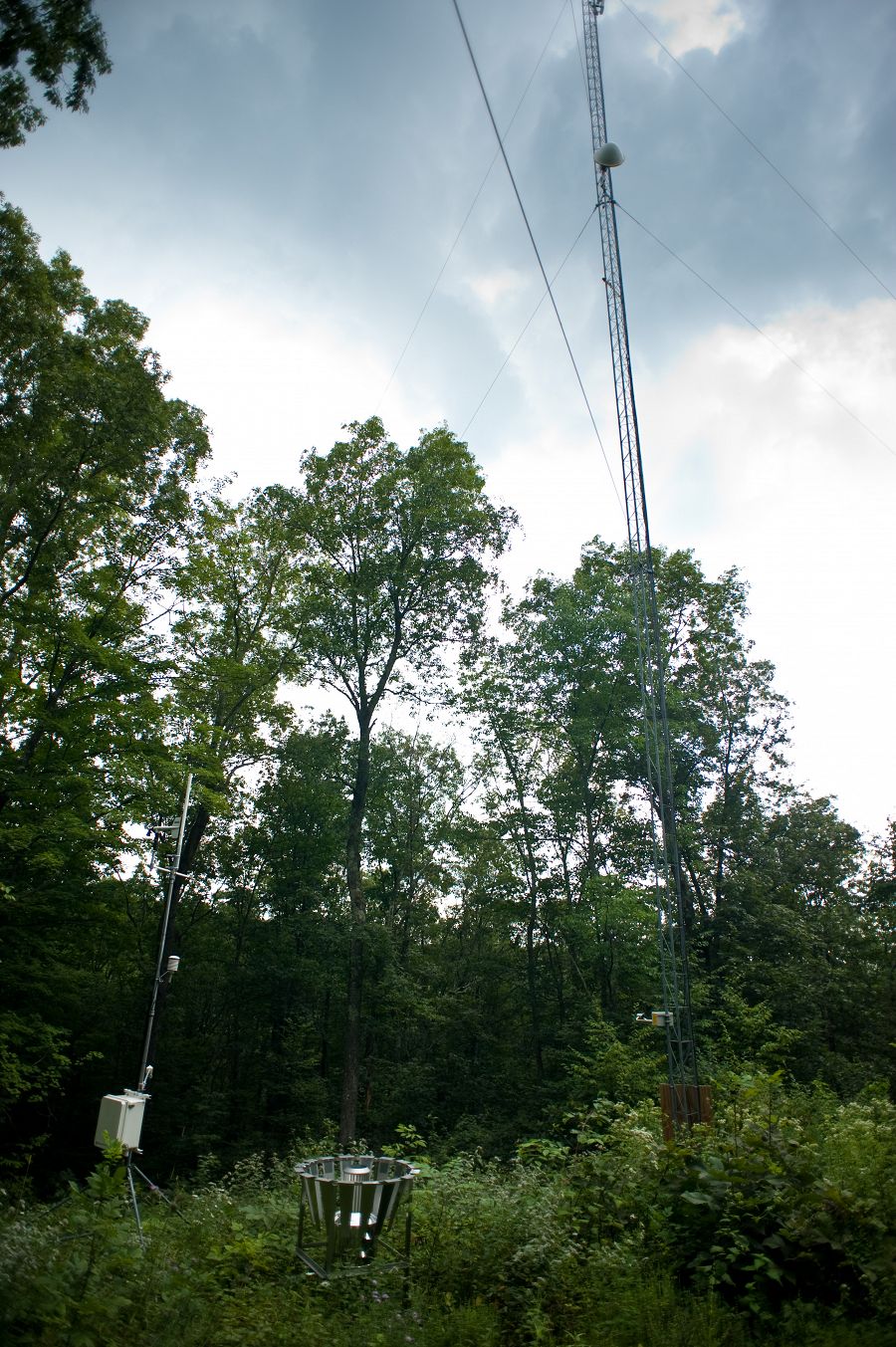
Image: Eddy flux tower and weather station on ridge top at the SSHCZO.
This group is tagged with:
Climatology / Meteorology
Hydrology
Modeling / Computational Science
-
Subsurface-land surface-atmosphere interaction: The instrument array at Susquehanna Shale Hills Critical Zone Observatory (SSHO) enables an unprecedented investigation of the subsurface-land-surface-atmosphere interaction. A fully-coupled hydrologic-land-surface model is developed and tested on SSHO to study the subsurface-land-surface interaction. The questions being researched include:
1) How does the hydrologic modeling system, driven by satellite observations and meteorological reananalyses improve the prediction of flood and drought conditions?
2) How does the fully-coupled hydrologic-land-surface modeling system improve the prediction of surface energy balance (SEB)?
3) What are the impacts of upland recharge, groundwater redistribution, root uptake of water, and water table fluctuations on SEB?
4) What are the impacts of vegetation (vegetation fraction, leaf area index, etc.) on hydrologic and land-surface systems?
5) How do the model parameter values affect the coupled processes in the modeling system?Groundwater, land surface and atmosphere are closely related to each others. A barrier to studying the subsurface-land-surface-atmosphere interaction is the lack of sufficient numerical model. Traditional hydrologic models have relatively simple land-surface schemes, while traditional land surface models (LSMs) are limited to vertical moisture transport in the soil column and ignore the deeper soil moisture processes and groundwater. The combination of local sensor arrays at SSHO provides valuable information for advance modeling. In particular, the eddy-covariance flux tower provides an opportunity to investigate the SEB and turbulence properties at SSHO and a primary means to evaluate model SEB simulations. A groundwater-land-surface model system has been developed from the Penn State Integrated Hydrologic Model (PIHM) by incorporating a land-surface component into PIHM. This land-surface scheme is mainly adapted from the Noah LSM, which is widely used in mesoscale atmospheric models and has undergone extensive testing. Because PIHM is capable of simulating lateral water flow and has deep groundwater, the new model is able to represent some of the land-surface heterogeneity caused by topography.
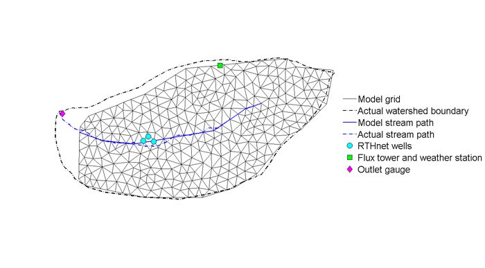
Figure 1. Grid setting for SSHO model domain. Locations of RTHnet wells, flux tower, weather station, and outlet gauge are also presented
At the same time, the robust land-surface scheme provides accurate sensible heat flux and evapo-transpiration rates. The new model has been implemented for the SSHO (Figure 1). It is manually calibrated to enhance its performance at this watershed. Model parameters including soil hydraulic conductivity, macropore hydraulic conductivity, soil porosity, van Genuchten soil parameters, and minimum stomatal resistance are tuned to fit the model outputs with both hydrologic and land-surface measurements. The model is driven by in situ measurements and North American Regional Reanalysis (NARR) dataset.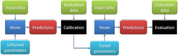
Figure 2. Flowchart of calibration and evaluation process.
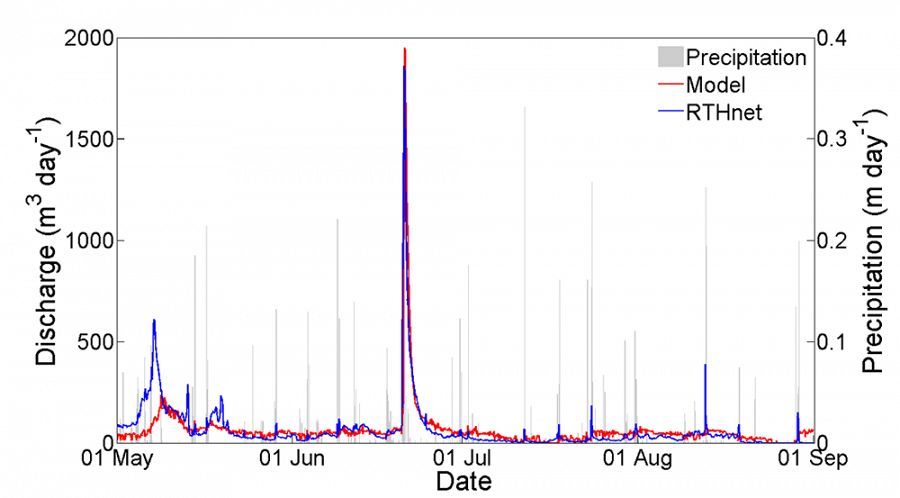
The model reproduces realistic topographically-induced distributions of water table, soil moisture, and skin temperature. The simulated river discharge shows good agreement with outlet gauge measurements (Figure 3).
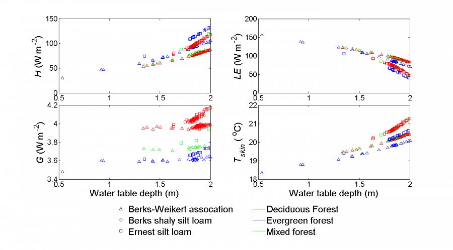
The sensible and latent heat fluxes simulated by the new LSM compare well with the eddy-covariance flux measurements on most days (Figure 4). Errors are relatively large when NARR fails to provide realistic radiation data. The model is able to capture the fluctuation of saturated and unsaturated water reasonably well. It therefore provides more realistic soil moisture variations which benefits the simulation of surface energy balance. The simulated sensible heat flux, latent heat flux, ground heat flux, and skin temperature are correlated with water table depth and are affected by soil type and land cover as well (Figure 5). The impact of soil type and land cover strengthens with the increase of water table depth.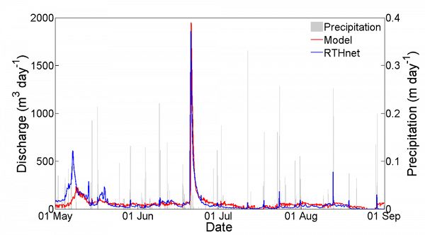
Figure 3. Comparison of hourly river discharge between model simulation and RTHnet measurements from 01 May to 01 Sept 2009.
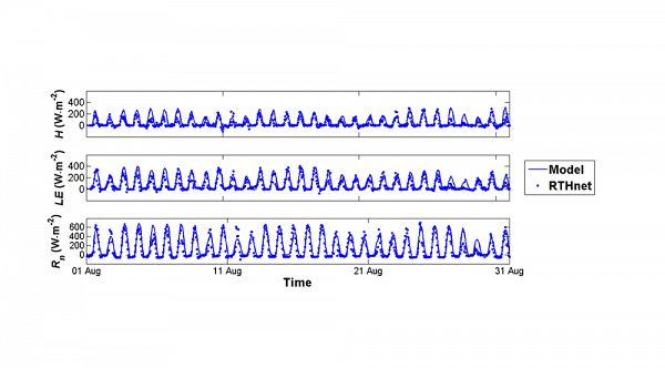
Figure 4. Comparison of sensible heat flux (H). latent heat flux (LE), and net radiation (Rn) (from top to bottom) between model and flux tower from 01 Aug to 01 Sept 2009.
This fully-coupled model of the atmosphere, land surface and subsurface may yield significant improvements in both flood/drought forecasting and in weather forecasting, and provide a valuable chance to study the subsurface-land surface-atmosphere interactions.
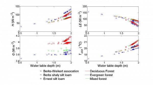
Figure 5. Simulated sensible heat flux, latent heat flux, ground heat flux (G), and surface skin temperature (Tskin) as functions of water table depth.
Hydroclimatology team: Kenneth Davis (PI, davis@meteo.psu.edu), Yuning Shi (PhD student, yshi@psu.edu), Burkely Twiest (undergraduate student, blt5086@psu.edu)
Figure 1. Grid setting for SSHO model domain. Locations of RTHnet wells, flux tower, weather station, and outlet gauge are also presented
Figure 2. Flowchart of calibration and evaluation process.
Figure 3. Comparison of hourly river discharge between model simulation and RTHnet measurements from 01 May to 01 Sept 2009.
Figure 4. Comparison of sensible heat flux (H). latent heat flux (LE), and net radiation (Rn) (from top to bottom) between model and flux tower from 01 Aug to 01 Sept 2009.
Figure 5. Simulated sensible heat flux, latent heat flux, ground heat flux (G), and surface skin temperature (Tskin) as functions of water table depth.
-
Contacts
-
Shale Hills, INVESTIGATOR
2 People

INVESTIGATOR
.(JavaScript must be enabled to view this email address)
Atmospheric carbon and hydrologic cycles

GRAD STUDENT
.(JavaScript must be enabled to view this email address)
Hydrological and land surface modeling
Alumni-Former
 .(JavaScript must be enabled to view this email address)
Cyberspecialist

GRAD STUDENT
Micrometeorology
-


Explore Further
